


An unpublished assessment suggests hydrological anomalies in the Madeira, Purus and Juruá rivers. The findings reveal where and when the water regime has become more unstable, showing a reduction in flow in almost half of the rivers analysed, and lead to one conclusion: attributing the anomalies to a single cause is a mistake.
Antônio Laranjeira (Carta Amazônia)
*A catfish trader on the Amazon River in the city of Leticia, Colombia. Credits: Gustavo Faleiros / InfoAmazonia
For riverside communities and fishing workers, who live between the mainland and the rivers of the Amazon, the rise and fall of each river’s water level determines access to lakes, the movement of fish, feeding grounds and the fishing calendar for the surrounding communities. The problem arises when this rhythm ceases to follow the expected pattern.
Science shows that when a river’s rhythm is disrupted, fishing in the Amazon loses its reference point. For those who fish, it is not enough to know whether there will be a lot or a little water. It is necessary to predict when the river will begin to rise, how long the level will remain high, and when the freshwater will begin to recede.
An integrated hydrological assessment and technical report produced by Renan Cassimiro Brito, who holds a master’s degree in Earth and Society Sciences from the University of São Paulo (USP), identified recurring episodes of exceptionally high or low flows in rivers associated with the presence of the dourada (dorado or gilded catfish), one of the Amazon’s main migratory catfish species and fishery resources.
The analysis was carried out as part of a collaborative research project between scientists and journalists, a partnership between the Serrapilheira Institute’s quantitative ecology training programme and the Latin American Centre for Investigative Journalism (CLIP). It involved participants from Brazil and other South American countries and resulted in the special project Divided Waters.

Brito compiled historical time series from 96 flow-measuring stations installed on major rivers and large tributaries between 2000 and 2024. At 45 of these – equivalent to 46.9 per cent of the network examined – there was a statistically significant trend towards reduced flow. The study also found signs of prolonged dry seasons and a significant drop in rainfall at 48 of the 153 rainfall stations assessed.
Rather than simply counting isolated incidents, the results allow us to observe when and where rivers deviated most markedly from their historical patterns. The main peaks occurred in 2004, 2009, between 2011 and 2015, in 2018 and again in 2024. Geographically, the most frequent records form a band concentrated in the south-west of the Amazon, particularly in the Madeira, Purus and Juruá river basins.
An anomaly does not simply mean drought
In this analysis, a hydrological anomaly represents a month in which the flow was significantly different from the behaviour normally observed during that season and at that time of year. The calculation compares each month with the monthly climatology for that specific monitoring point.
This calculation works as follows: a given January is compared with all other Januaries in that season, rather than with the dry or wet months of the same year. In this way, it is possible to distinguish between a river’s normal fluctuations and statistically unusual behaviour.

If the water level rises or falls significantly beyond the norm, a warning signal is triggered. When this deviation is very large, we call it a severe event. If it is completely out of the ordinary, it becomes an extreme event. This rule applies equally to both historic floods and historic droughts.
This means that an anomaly is not automatically synonymous with drought. A flood that is much higher than expected can also be considered anomalous. The same applies when the ebb begins before the usual period, when the flood is slow to arrive, or when the river remains below a critical threshold for a longer period.
“The classification is a tool for understanding how flow behaves over time, and not necessarily the factors that directly influence it,” explains Brito. According to the researcher, the results act as “a barometer of where and when the flow proved to be most unstable”. The analysis detects the deviation, but does not in itself determine what caused it.
The map of instability
A combined analysis of the 25-year time series reveals that these episodes are not evenly distributed across the Amazon basin.
The peaks in 2004 and 2009 were followed by a more persistent sequence between 2011 and 2015. A further increase occurred in 2018 and another in 2024. The extreme anomalies, although less frequent, roughly coincide with the same periods of intensification as the severe ones.
Geographically, the areas with the highest recurrence rates are found mainly in the south-western Amazon. This region encompasses the Madeira River, which rises from the confluence of major Andean rivers and flows through the Brazilian states of Rondônia and Amazonas, and the Purus and Juruá basins, two of the main river systems in the western Amazon.
The map highlights the main channels of the Purus, Juruá and Madeira rivers (in red) and a waterway connecting them with other rivers (in blue) that serve as migration routes for Amazonian fish. Credits: Antônio Laranjeira
It is also a key region for fishing migratory fish species, such as the dorado catfish. Rivers, floodplain lakes (varzeas), canals and floodplain forests form habitats used at different stages of the fish’s life cycle. When the duration or timing of floods changes, these habitats may remain connected for a shorter period or be accessed at different times than usual.
The study does not specify whether each anomaly was positive or negative in each catchment, nor does it measure its effects on fish landings. What the data show is the recurrence of unusual patterns precisely in a region where the water cycle sustains artisanal fishing networks, urban markets and the movement of species between Brazil, Peru and Bolivia.
When the water changes, fishing feels the effects later
The relationship between water fluctuations and fishing is not always immediately apparent.
During regular floods, fish enter lakes, floodplains and flooded forests, where they find food, shelter and areas to grow. An article published in 2016 suggests that years with intense flooding may improve feeding conditions and increase the biomass available for catch in subsequent periods. Conversely, severe droughts can increase natural mortality, concentrate fish in smaller areas and increase fishing pressure.
Consequently, a change recorded in a given year may affect recruitment, growth and the quantity of fish available only in subsequent fishing seasons. This time lag makes it difficult to perceive the crisis immediately and prevents a decline in landings from being explained solely by river conditions at the time of capture.
For migratory species, predictability is particularly important. Rising water levels, current strength, temperature and other environmental cues all play a part in guiding reproductive movements. The dorado catfish relies on these connections to traverse different parts of the basin during its life cycle.

The species was the focus of a previous InfoAmazonia story on the barriers created by the Santo Antônio and Jirau hydroelectric dams on the Madeira River. The new analysis adds another dimension to the problem: even in stretches where passage remains physically possible, the fish encounter a water regime subject to recurring episodes of instability.
The assessment did not measure the dorado’s response to these anomalies. The overlap between hydrological data and the species’ fishing, spawning and growth areas still needs to be investigated. The concern lies in the accumulation of pressures: reduced flow, more prolonged droughts, fishing for juvenile fish, loss of connectivity and barriers along the routes.
From anomaly to fishing insecurity
Fishing insecurity does not merely mean the complete absence of fish in the nets. It also manifests itself when fishermen can no longer predict where and when species will be available, have to travel greater distances, or spend more days on the river to obtain smaller catches.
This instability can increase expenditure on fuel, ice, food and boat maintenance. It can also shift fishing towards smaller or less valuable species, drive up market prices and reduce the amount of protein available to families who rely on direct consumption.
Map showing the location of hydroelectric power stations along the main waterways of the Amazon basin and highlighting the impacts of these dams on river connectivity. Credits: Antônio Laranjeira
A scientific review article published in 2021 on migratory fish estimated that these species account, on average, for around 93 per cent of the fish landings analysed in the Amazon basin. This dependence helps explain why changes in river flow patterns are not merely an ecological problem: they affect the income, food supply and food security of urban, indigenous and riverside communities.
On the Madeira River, a 2020 scientific article compiled data from studies carried out before and after the commissioning of the Santo Antônio and Jirau hydroelectric dams, which have already led to a decline in catches, a reduction in fishermen’s incomes and a deterioration in the ecological and social indicators of small-scale fishing. The losses were greater amongst fishermen than amongst middlemen and traders, demonstrating that the impacts are not distributed equally across the production chain.
Another study, published in 2019 and based on monitoring of fishermen some 1,500 kilometres upstream of the power stations in Bolivia, found a significant decline in dorado catches following the closure of the dams. The few individuals found are thought to be a combination of older fish, which had migrated upstream before the dams were built, and populations born upstream of the dams that became isolated in the upper part of the basin.
These studies demonstrate that hydroelectric power stations can affect fishing and connectivity. They do not, however, demonstrate that the anomalies detected in the new assessment were caused by these same power stations.
Hydroelectric power stations are part of the equation
The presence of the Santo Antônio and Jirau power stations on the Madeira River makes it inevitable to question whether the operation of these power stations has contributed to some of the deviations observed. Dams can alter the magnitude, duration, frequency and timing of flows, as well as changing the connection between the river channel and its floodplains.
In the Tocantins basin, for example, a scientific analysis published in 2021 compared the periods before and after the construction of dams and identified a reduction in the extent and duration of floods, as well as changes in the onset of flooding. The authors attributed most of the changes to the operation of the power stations, having also assessed rainfall and changes in land cover.
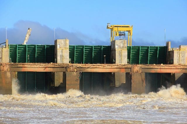
However, science also has its limitations, despite its certainties, and warns against assertions lacking scientific evidence. In the case of the assessment of the catchment areas associated with the dourada, this step of attribution was not carried out.
“It is common to associate these fluctuations with possible human-induced disturbances in the catchment, such as the operation of hydroelectric power stations,” says Brito. “But to make a direct attribution of cause and effect, a specific analysis correlating these events with operational data would be necessary,” explains the environmental scientist.
Such a cross-analysis would require gathering, amongst other information, the flow entering and leaving each reservoir, storage levels, the water released by turbines and spillways, and the dates of operational manoeuvres. The data would need to be compared with precipitation, temperature, deforestation, land-use changes and weather conditions upstream and downstream of the dams.
The concentration of anomalies also extends to the Purus and Juruá rivers, not just the Madeira. This pattern prevents a single explanation from being applied to the entire area and reinforces the need to distinguish the effects of hydroelectric operations from climatic signals and cumulative changes in the catchment areas.
A predictable river is also infrastructure
Fisheries management typically establishes closed seasons, minimum sizes and restrictions on equipment. These rules are based on the assumption that reproductive and hydrological cycles will continue to occur at relatively predictable times.
When a river begins to behave differently, the administrative calendar may no longer coincide with the ecological calendar. A species may begin its migration before or after the protected period. A floodplain (varzea) area may dry up before juveniles have fully grown. An unseasonal flood may alter fishing and landing sites.
The analysis does not conclude that these processes are already occurring in all the basins analysed. It provides a basis for future research to verify this relationship, by combining flow data with landing figures, fishing effort, fish size and hydroelectric power station operations.
![IMG_20170518_074931382[1]](https://b4716978.assetcdn.net/2.0/4716978/wp-content/uploads/2026/09/img-20170518-0749313821.jpg?lossy=2&strip=1&webp=1)
The results show, however, that the unusual behaviour of the rivers is no longer a phenomenon restricted to a single year or location in the Amazon. The peaks recurred at different times and were concentrated in basins that are essential for fish migration and for the livelihoods of local communities.
For the fishing industry, preserving the river means more than just keeping water within the riverbed. It means preserving the sequence, duration and timing of the floods and ebb tides. When this cycle becomes unstable, fishermen and fish lose a shared point of reference.
Scientific references for the report
Brito, R. C. (2026, 20 June). Integrated hydrological assessment: Bacia Dourada, main variable: discharge (m³/s) [Technical report].
Doria, C. R. C., Dutka-Gianelli, J., Brasil de Sousa, S. T., Chu, J., & Garlock, T. M. (2021). Understanding the impacts of dams on small-scale fisheries in the Madeira River through the lens of the Fisheries Performance Indicators. Marine Policy, 125, 104261. https://doi.org/10.1016/j.marpol.2020.104261
Duponchelle, F., Isaac, V. J., Doria, C. R. C., Van Damme, P. A., Herrera-R., G. A., Anderson, E. P., Cruz, R. E. A., Hauser, M., Hermann, T. W., Agudelo, E., Bonilla-Castillo, C., Barthem, R., Freitas, C. E. C., García-Dávila, C., García-Vasquez, A., Renno, J.-F., & Castello, L. (2021). Conservation of migratory fishes in the Amazon basin. Aquatic Conservation: Marine and Freshwater Ecosystems, 31(5), 1087–1105. https://doi.org/10.1002/aqc.3550
Faleiros, G. (2019, 8 April). Dams on the Madeira River could spell disaster for the Amazon’s giant catfish run. InfoAmazonia. https://infoamazonia.org/2019/04/08/represas-do-rio-madeira-podem-significar-a-desgraca-da-maratona-de-grandes-bagres-da-amazonia/
Isaac, V. J., Castello, L., Brasil Santos, P. R., & Ruffino, M. L. (2016). Seasonal and interannual dynamics of river-floodplain multispecies fisheries in relation to flood pulses in the Lower Amazon. Fisheries Research, 183, 352–359. https://doi.org/10.1016/j.fishres.2016.06.017
Swanson, A. C., Kaplan, D., Toh, K.-B., Marques, E. E., & Bohlman, S. A. (2021). Changes in floodplain hydrology following serial damming of the Tocantins River in the eastern Amazon. Science of the Total Environment, 800, 149494. https://doi.org/10.1016/j.scitotenv.2021.149494
Van Damme, P. A., Córdova-Clavijo, L., Baigún, C., Hauser, M., Doria, C. R. C., & Duponchelle, F. (2019). Upstream dam impacts on the gilded catfish Brachyplatystoma rousseauxii (Siluriformes: Pimelodidae) in the Bolivian Amazon. Neotropical Ichthyology, 17(4), e190118. https://doi.org/10.1590/1982-0224-20190118

This project is the result of a collaboration between Latin American journalists and scientists, spearheaded by Brazil’s Serrapilheira Institute and the Latin American Center for Investigative Journalism (CLIP), to explore the Atlantic-Amazon-Andes water pathway and the disruptions to the ecosystem services it provides to the continent.


