


Fought for decades, these formations in southwestern Rio Grande do Sul help secure water for the region’s residents. They are part of a complex hydrological cycle that links rain originating in the Amazon to the Guarani Aquifer System.
Veridiana Dalla Vecchia (Correio do Povo)
*A sand barren in Manoel Viana. Photo: Veridiana Dalla Vecchia
Seen from a distance against the vast green expanse of the Pampa, framed by rolling grassy hills, they look almost identical: patches of soil in shades ranging from light brown to reddish pink and orange. It is winter, long after the soybean harvest, and a secondary cover crop hugs the ground. Step closer, however, and each areal — or sand barren — reveals a distinct anatomy. One patch outside the town of São Francisco de Assis forms a rounded contour of sand and stones — or rocks, as I was gently corrected by the geographers and geography students accompanying me during a June visit.
At the Areal Redondo (Round Sand Barren), as it is known among researchers and students at the Federal University of Rio Grande do Sul (UFRGS), sandstone rocks litter the landscape and vegetation is virtually non-existent. Across this 48,743-square-meter expanse — roughly the size of seven soccer fields — one can find armadillo burrows, animal tracks, and fulgurites: slender tubes formed when lightning strikes sand, a frequent phenomenon in this area.
For decades, farmers, scholars, and government agencies battled these barren patches across the grasslands of Rio Grande do Sul, seeking plant species or techniques to halt what they presumed to be an advancing desert. In reality, these sand barrens form an integral link in a complex hydrological cycle connecting the Amazon, the Atlantic Ocean, and the Pampa—a vital process for human and animal survival alike. Spanning nearly 5,000 hectares across ten municipalities in southwestern Rio Grande do Sul, these sparse, fragile ecosystems allow rainwater to infiltrate the sandy soil and recharge the Guarani Aquifer System (SAG).


In São Francisco de Assis, as in the nine other municipalities with sand barrens, about a quarter of the total rainfall comes directly or indirectly from the Amazon, while another 14 percent originates from the Atlantic Ocean. These estimates were produced for this report by Sandro Pauli Jr., a physicist at the Federal University of Santa Catarina and a specialist in climate models that track atmospheric moisture. Pauli, a fellow in the Serrapilheira Institute’s quantitative ecology training program, mapped the water’s trajectory step by step using a computer model that tracks atmospheric moisture transport.
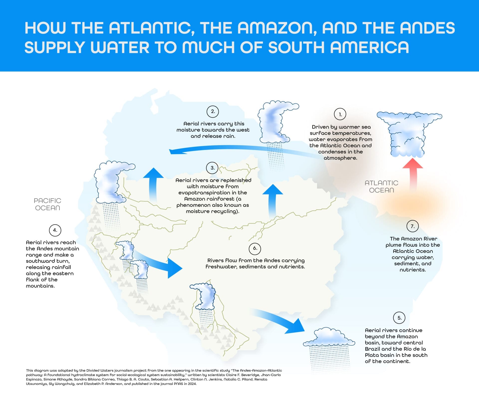
Fourteen percent of all rainfall landing on the sand barrens recharges the Guarani Aquifer System, according to measurements by Jean Carlo Caneppele, a geographer doing postdoctoral research at the Federal University of Rio Grande do Sul. Because sand barrens filter water and help protect native flora and fauna, researchers argue they should be recognized for providing environmental services. Such recognition could integrate sand barrens into public conservation policies and Payment for Environmental Services (PES) programs that benefit local rural landowners. “It’s a unique phenomenon in Brazil, found only within these ten municipalities in Rio Grande do Sul,” Caneppele explains. “These are ecosystems with their own distinct fauna and flora, so there’s no need to fight them.”
Caneppele — a member of the Sand Barren/Desertification Research Group at UFRGS, registered with Brazil’s National Council for Scientific and Technological Development (CNPq) — is referring to how sand barrens were viewed for decades as a major concern and source of conflict, long presumed to be driven by advancing desertification. Today, however, researchers have established that many of these formations have existed for thousands of years as distinct ecosystems. By contrast, others stemmed from poor land management and can trigger severe erosion, particularly amidst a climate emergency characterized by more frequent droughts and heavier rainfall.
WHEN THE PAMPA WAS A DUNE
Beyond São Francisco de Assis, these sand barrens are found in the municipalities of Alegrete, Cacequi, Itaqui, Maçambará, Manoel Viana, Quaraí, Rosário do Sul, São Borja, and Unistalda. Concerns about these formations intensified in the 1970s with the expansion of soybean farming into the biome. From that point on, it was widely assumed that the sand barrens were merely the result of poor land management—a clear sign of advancing desertification.
However, in 1987, Dirce Suertegaray, then a doctoral candidate in geography at the University of São Paulo (USP), established that these formations were, in fact, natural. A pioneer in this field of research, Suertegaray — now a visiting professor at the State University of Amazonas (UEA) and a collaborating professor in the graduate geography program at the Federal University of Paraíba (UFPB) — demonstrated that the processes occurring in this biome did not fit the profile of desertification.
“At the time, people claimed that soybean farming was driving the expansion of the sand barrens, but the site [being studied in Quaraí, near the Uruguayan border] was not in a soybean-producing region, and it already existed,” says the geographer, who is also professor emerita at the Federal University of Rio Grande do Sul. She also identified other similar sites that had been documented long before the arrival of agriculture, including those in Alegrete and São Francisco de Assis.
The distinction lies in the local rainfall. The first United Nations Conference on Desertification, held in Kenya in 1994, defined desertification as land degradation in arid, semi-arid, and dry sub-humid areas resulting from factors ranging from climate variability to human activity.
Dirce explains that the phenomenon in Rio Grande do Sul cannot be classified as desertification because it doesn’t fit the climatic criteria for at-risk areas, given the region’s high levels of rainfall. Furthermore, the state’s sandy areas form ecosystems that, while fragile and under intense social pressure, are not degraded land. This does not mean, however, that there are no degraded areas near the sand barrens, or that erosion from improper land use cannot create new sandy patches.
The sand barrens are products of climate change—though not the current crisis we face today. They are remnants of the Late Jurassic period, some 160 million years ago, when the Pampa was arid and covered in dunes, and giant dinosaurs roamed the supercontinent Pangaea. Over centuries and millennia, rising humidity allowed vegetation to develop and take on its present-day characteristics. The sand barrens stand as a testament to that dry era—and a warning about the fragility of Brazil’s most devastated biome, which, according to the scientific data platform MapBiomas, lost 45.6 percent of its native vegetation between 1985 and 2024.
The sand barren in São Francisco de Assis, mentioned earlier, is approximately 15,000 years old, according to studies on wind dynamics and sand remobilization by the Sand Barren/Desertification Research Group (Grupo de Pesquisas em Arenização/Desertificação).
“The technique is complex, but relatively simple to understand: essentially, when sand is exposed to the sun, it absorbs radiation. When a new layer of sand covers it, that previously exposed sand falls into shadow and the radiation level drops. This method allows us to calculate how long the sand was exposed and when it was buried. That lets us date the sand barrens, and the oldest ones identified so far go back 15,000 years,” explains Roberto Verdum, a professor in the Geography Department at the Federal University of Rio Grande do Sul (UFRGS).
“This marker is revealing because global and regional research has established that the last cold, hyper-arid period spanned from 18,000 to 10,000 years ago, peaking around 18,000,” he explains. “So 15,000 years ago falls squarely in that window.” Verdum notes that the newest sand barren dated by the team is only about 200 years old — a date that neatly coincides with the Little Ice Age, another interval of widespread cold and drought.
Verdum explains that sand-barren formation is a process in which sandy deposits of fluvial and wind-driven origin form in association with factors such as climate, terrain, and vegetation cover. It may or may not be linked to farming activity. He attributes the origin of these sandy patches to the susceptibility of the Pampa’s rocks and soils, combined with the dynamics of torrential rains and dry spells. “The effects of poor land use and management, employing technologies ill-suited to this region’s fragile soils, can be one of the main factors contributing to the emergence of new sand-barren hot spots,” the geographer warns.

THE SAND BARRENS PULSE
Because these formations exist within a fragile biome, there was long-standing concern that the sand barrens were expanding, based on observations of a steady, ongoing process of formation. Today, however, scientific evidence shows the total area of the sand barrens is not expanding. According to a 2023 measurement by the Sand Barren/Desertification Research Group, they cover roughly 5,000 hectares (50 square kilometers)—an area twice the size of Fernando de Noronha, or slightly smaller than San Marino (6,120 hectares).

These concerns were not unfounded: the dunes did expand throughout the 1980s and 1990s, before beginning to retreat in the 2000s. Researchers later discovered that these landscapes ‘pulse,’ as Professor Roberto Verdum describes it, expanding and contracting with regional cycles of drought and rain.
“The monitoring we’ve carried out since 1987 — in 1994, 2001, 2011, and now in my 2023 dissertation — shows that the sand barrens don’t expand. They grow and then shrink depending on weather conditions,” says Caneppele, the author of the doctoral dissertation Hydrological Environmental Services of Sand-Barren Formation. To understand these dynamics, the researchers observed the behavior of one such formation in the municipality of São Francisco de Assis, taking periodic measurements of its edges over the course of a year using precision GPS and staking techniques.
“During dry spells, the sand barren tends to grow because the vegetation around and inside it suffers from a lack of water. In sandy soil, less rain means the ground dries out more,” Verdum explains. That directly affects plant growth, particularly the herbaceous vegetation with its shallower roots. “But then the wet period comes—the wettest time of the year, or years with more moisture—and the sand barren shrinks. Its edge can retreat by 10 or 11 meters, only to grow again. So it pulses in response to these short-term variations.”
This pulse is also visible from above. Satellite measurements help visualize the dynamic, showing the sandy areas growing in the 1990s, shrinking in the 2000s, and expanding again in the 2010s. Enzo Gonçalves Luciano, a forestry engineer from the Federal University of Santa Catarina with a master’s degree in science, compiled the MapBiomas fluctuation data for this report. He is part of the Serrapilheira Institute’s training program in quantitative ecology, a partner organization in the Águas Partidas (Divided Waters) investigation, coordinated by the Centro Latinoamericano de Investigación Periodística (CLIP) in partnership with eight news outlets from the region.
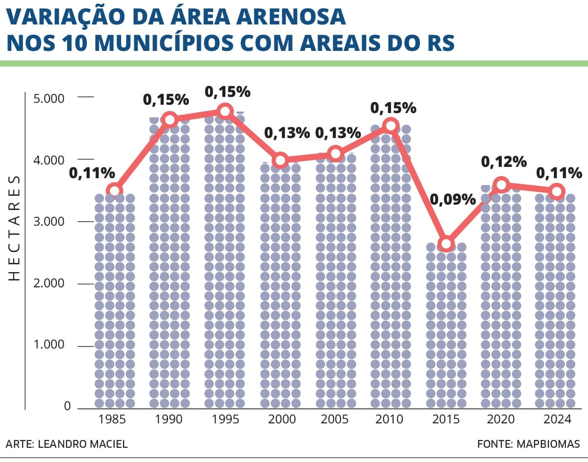
This chart illustrates how the area covered by sand barrens has evolved in five-year intervals from 1985 to 2024. The data is drawn from MapBiomas Collection 10, which uses the “Beach, Dune and Sand Barren” classification derived from 30-meter resolution Landsat satellite imagery. The figures represent the total area mapped across the ten municipalities known for these formations. In addition to area in hectares, the chart shows the percentage relative to the total analyzed area each year, allowing for historical trend comparisons.
To illustrate how sensor resolution affects results, Luciano compared two 2023 MapBiomas datasets. The Landsat collection (30-meter resolution) indicated 3,459.5 hectares — 0.11 percent of the analyzed area — while Sentinel-2 mapping (10-meter resolution) estimated 9,498.9 hectares, or 0.31 percent.
Because of this discrepancy, satellite data remains an essential but incomplete tool; some dynamics of sand-barren formation can only be understood on the ground, as satellite imagery often fails to capture conditions beneath tree canopies.
“The satellite, in a vertical view, reads the surface based on temperature. So eucalyptus, being a vegetation cover, blankets the sand barrens and obscures their reflectance,” says Dirce Suertegaray. The researcher specifically highlights eucalyptus because, for years, public authorities heavily encouraged planting it to contain what was then believed to be an expanding desert. It was also seen—and in part still is—as a viable income source for producers through timber sales for pulp.
However, the geographer points out that erosion continues to develop within eucalyptus plantations. “There’s evidence of water dynamics at work [in eucalyptus-planting regions], with many gully formations and sometimes full ravines, even causing eucalyptus trees to fall, because the soil is so fragile.” Gullies are furrows that form across open land, acting as channels for water drainage. Over time, they can deepen until they reach the water table, becoming ravines.
With soil prone to sand-barren formation, some areas may not be consolidated barrens, but rather degraded land, or land in the process of degrading, because of improper use and management. Distinguishing these areas from natural, consolidated sand barrens is essential for creating appropriate public policy for restoration or preservation. Caneppele explains that the Sand Barren/Desertification Research Group is now mapping these areas by identifying formations that predated the introduction of modern farm machinery and intensive ranching. To determine what the Pampa looked like prior to the 1970s, the group analyzes literature and historical accounts.
The French naturalist Auguste Saint-Hilaire, for instance, wrote about the Quaraí region in 1822 in his Journey to Rio Grande do Sul: “A very flat region, sandy and stony ground, excellent pastureland, but where the grass is low and sparse; still some vegetation, but no flowering plants […]. No houses or cattle; yet there were once many ranches here, entirely destroyed during the war. […] Small trees and shrubs grow there, forming a very dense grove, and around it stiff, tall grasses belonging to the composite family can be seen.”
“There are aerial photographs from 1940 and 1960. What shows up in the 1960 photographs is a natural sand barren, because there was no machinery in the 1960s. It was extensive ranching, and extensive ranching doesn’t produce sand barrens. So we’re acquiring the Army’s database, and now we have to do all the mapping, overlaying these images — we’re working on that,” Caneppele says.
It is worth noting that when researchers label these formations “natural,” it does not imply they were free of human influence. Rather, it means they are sand barrens that consolidated over time. Verdum argues that defining the landscape as strictly “natural” or “cultural” can be a “trap.” “The landscape is already a hybrid, given the scale of human, or social, interventions at various levels — from the local to the global. So, to me, the landscape is exactly this interface between dynamic elements, including nature and human societies, across history.”

NOTHING TO RESTORE
The total area covered by sand barrens may be small compared with the full extent of the Pampa — under 5,000 hectares out of a biome that spans 19.4 million hectares. But it can matter a great deal to each individual landowner whose property is affected by the phenomenon, since nothing can be planted or raised there. That is also why, for decades, people tried to “restore” the sand barrens.
“At the start of the research [in the 1980s], there was a view that sand barrens were something bad that had to be fought — it was primarily an agronomic paradigm aimed at preventing the sand barrens from expanding. But today we know they do not expand,” Caneppele explains. “It has been more than 35 years of asserting that this is not degradation, that what happens in the Pampa is natural.”
The geographer, who has worked on sand barrens for 14 years, defended his doctoral dissertation in 2023, explaining how these formations provide a vital service to Rio Grande do Sul: serving as a recharge area for the Guarani Aquifer System. “When we noticed their dynamic of remaining stagnant, it clicked: ‘Wait, if they are just sitting there and not expanding, they must be providing some kind of environmental service.’”
Caneppele noticed that the sand-barren hot spots and the aquifer’s recharge areas overlapped. Measurements later confirmed that water infiltrates the sand barrens, which then filter it and recharge the aquifer. “We found that 14 percent of Rio Grande do Sul’s average rainfall recharges the aquifer. So, it is not the case that 100 percent of what enters the sand barrens goes on to recharge it.” The geographer notes that water seeping through the sand barrens is free of pesticides, unlike water that filters through soil where crops are grown. “There is nothing contaminating the sand barrens. It is preserved soil. So, in theory, the water that falls there enters clean.”


Understanding the sand barrens as providers of environmental services opens the door to public policies that recognize their economic value. One possibility would be to include these formations in a Payment for Environmental Services (PSA) mechanism, where rural landowners who adopt conservation and sustainable management practices could be financially compensated. Caneppele studies the water-filtering service, but the sand barrens provide other services as well. “You can have environmental services tied to biodiversity or landscape. There is a movement underway to turn the Quaraí sand barren into a conservation unit and tourist route because it is such a distinctive place. There are already tours of the sand barrens.” The state government’s website lists the Sítio Complexo do Areal, or simply Sítio do Areal, as a tourist destination in Rio Grande do Sul, located on the state’s western border.
These small patches of land function as points where rainwater infiltrates the ground, feeding one of the world’s largest underground reservoirs, the Guarani Aquifer System. “We developed a new paradigm — not just in my dissertation, but among a whole group of researchers — that if the sand barrens are natural, the paradigm should be to conserve them. We are also dealing with a capitalist economic model that presupposes use.”
The hydrological services provided by the sand barrens could be worth up to 11.3 million reais ($2.2 million) a year, according to calculations from Caneppele’s dissertation. To arrive at that figure, the geographer used a water treatment cost of 0.85 reais per cubic meter and multiplied it by the sand-barren area that recharges the aquifer and the estimated 14 percent recharge rate of rainfall. This produced a total of 8.3 million reais ($1.6 million) a year, assuming annual rainfall of 1,400 millimeters, and 11.3 million reais a year for 1,900 millimeters of rainfall.
The geographer argues that this valuation can provide a basis for creating PSA public policies, giving rural producers — especially small-scale ones who help protect the sand barrens and their natural components — access to income.
Sand barrens end up being unproductive land that generates no income for a family, ultimately causing economic losses for small producers. Therefore, Caneppele’s idea is to promote and introduce rural landowners to environmental services, weaving the conservation of the sand barrens into an economic chain so that their water-filtering service has monetary value. That valuation, the geographer says, would incentivize rural producers to stay on their land.
Currently, the crop best suited to the region’s sandy soils is eucalyptus, which many producers rely on for income from selling timber for pulp production. But forestry also impacts a region consisting mainly of grasses and shrubs. Last year, the state government published the Environmental Zoning for Forestry (ZAS), which sets guidelines for forestry activity in Rio Grande do Sul, aiming to conserve natural ecosystems against the potential environmental impacts of this economic activity.
According to the document, sand barrens classified as not yet consolidated can be utilized, provided it is done with proper management aimed at stabilizing the sand barren and generating economic benefits. Consolidated areas located within forestry projects, however, must be treated as a Legal Reserve, requiring a protective buffer aimed at conserving fauna, flora, and the landscape. Currently, the consolidated sand barrens are identified in the “Atlas of Sand-Barren Formation: Southwestern Rio Grande do Sul” (“Atlas da arenização: sudoeste do Rio Grande do Sul”, 2000), compiled by geographers Dirce Suertegaray, Laurindo Antonio Guasselli, and Roberto Verdum.
Although at first glance the Pampa’s grasslands and sandy areas may not seem to hold much biodiversity, that impression is misleading. The grasslands of Rio Grande do Sul are home to 12,503 species of fauna, flora, fungi, and bacteria, corresponding to about 9 percent of those currently known in the country. The data was published in January in the international journal Frontiers of Biogeography and is part of a large study co-authored by more than 120 researchers from 70 different institutions.
According to the study, 622 species are classified as critically endangered, endangered, or vulnerable. Twenty-three species are already considered extinct in the biome, 17 of which are plants. Still, much remains unknown about the degree of threat facing these species. The study notes that only about a third of the registered species have been studied enough to determine their status.
For the sand-barren region of southwestern Rio Grande do Sul, a data cross-analysis carried out for this report by forestry engineer Enzo Gonçalves Luciano linked the presence of these sandy ecosystems to biodiversity records and priority conservation areas designated by Brazil’s Ministry of Environment (MMA). The map shows that several threatened species are found in or near sand-barren areas, underscoring the importance of preserving these local ecosystems.
Luciano delineated the ten municipalities with sand barrens based on Caneppele’s dissertation and mapped the sandy areas according to MapBiomas Collection 10 (2024). Given the limited spatial extent of these environments, a five-kilometer influence zone around the sandy formations was used to search for records of threatened species. The species were compiled from the database of GBIF — the Global Biodiversity Information Facility — and speciesLink, a South American digital infrastructure created to integrate and share scientific biodiversity data.
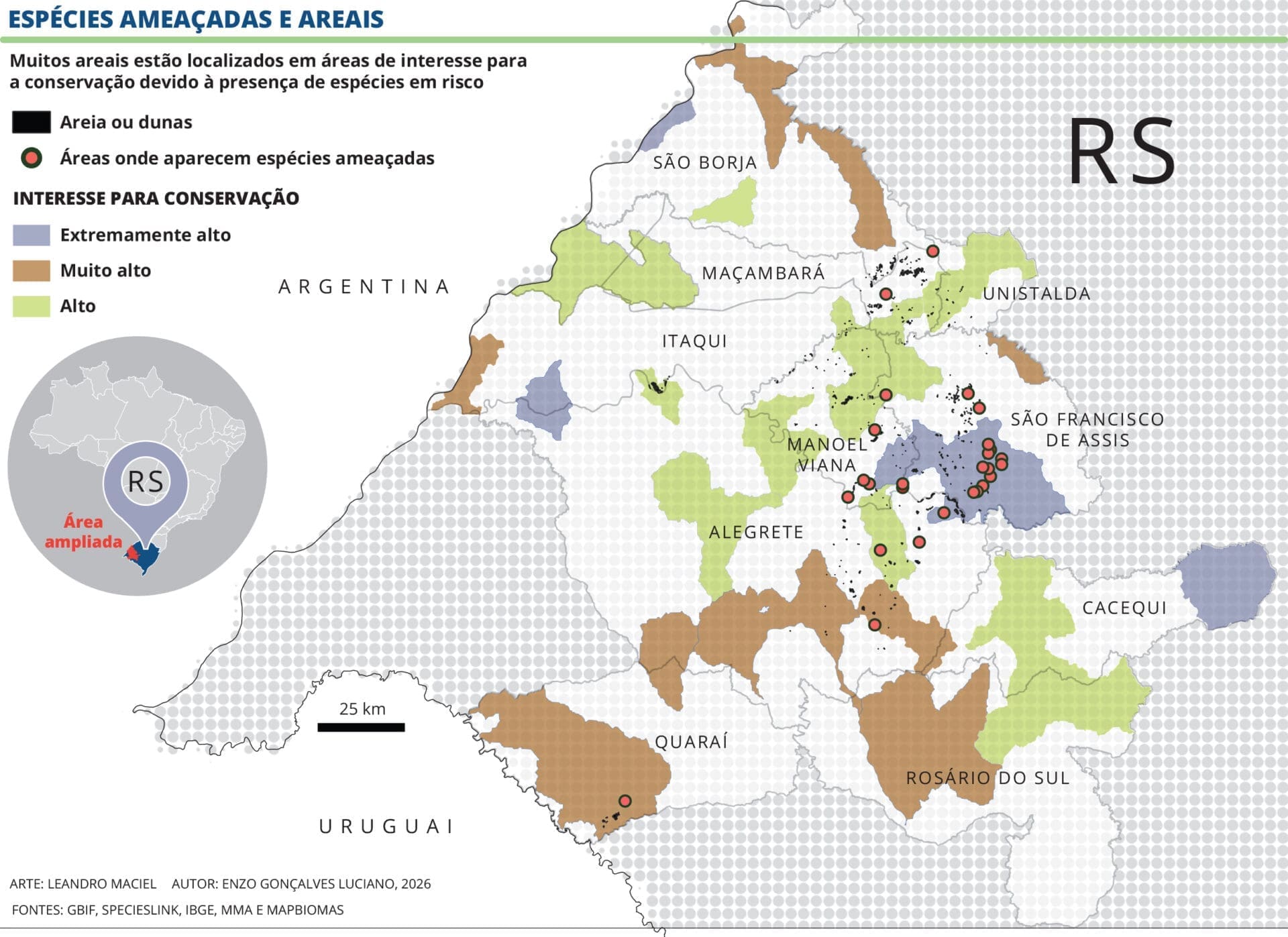
The map shows only the occurrence of species classified as Vulnerable (VU), Endangered (EN), and Critically Endangered (CR) according to national and international conservation lists, supplemented by information from Flora e Funga do Brasil to verify the endemism of plant species. It also incorporates an overlay of the MMA’s Priority Areas for Conservation of the Pampa Biome, integrating information on the distribution of sandy ecosystems, threatened biodiversity, and priority conservation areas.
Countless native and endemic species — meaning they occur only in a particular region — or species adapted to sandy grasslands are associated with the sand barrens. Among those commonly found in these formations are the spiny lizard (Tropidurus catalanensis), the dwarf butiá palm (Butia lallemantii), and lemongrass (Elyonurus sp.).
Among fauna species at some level of threat, according to Luciano’s survey, are the brown howler monkey (Alouatta guariba), the rock gecko (Homonota uruguayensis), and the pampas cat (Leopardus colocolo). Among flora, cactus species such as Echinopsis oxygona and Parodia ottonis are at risk.


According to researchers like Verdum and Caneppele, the biological diversity found in and around the sand barrens shows that sand-barren formation should not be regarded as environmental degradation. Social patterns of land occupation, however, can accelerate erosion and the loss of native fauna and flora.
CLIMATE CHANGE AND DEGRADATION
“You know what I did? Friday, I took the cattle to auction and sold everything.” The decision by rancher Cevi Siqueira, of São Francisco de Assis, in southwestern Rio Grande do Sul, to get rid of his 28 animals in June was in response to forecasts of a super El Niño expected to begin between July and September of this year. “If what happened last time occurred, imagine now.” He is referring to 2024, when a combination of weather phenomena brought the state its worst climate disaster on record. That year, more than 6 million people were affected, according to a survey released in July of this year by the Brazilian Institute of Geography and Statistics (IBGE), across 478 municipalities, due to excess rainfall that caused flooding, landslides, and flash floods. The State Civil Defense agency counted 185 deaths, and economic losses are estimated in the billions of reais.
That year, Siqueira had to move his animals to a neighbor’s land to protect them from the floodwaters invading his property. Even then, he lost nine cows. The water level came within 20 centimeters of his house, and he waited 12 days for it to recede. Once the waters finally drained, there was no food left for the livestock, as the pasture had rotted away. Now, he has decided to play it safe: he has kept only the sheep, because ‘you can just load them into a pickup and drive them away.’

Due to the fragile nature of the soil, the sandy terrain in this part of Rio Grande do Sul is highly susceptible to water and wind erosion. Roberto Verdum notes, for instance, that a massive ravine opened up in São Francisco de Assis during the severe El Niño event of 1983–1984. Back then, the intense rainfall caused dams to overflow, with the surging water carving deep furrows into the landscape. Today, the ravine resembles a canyon, stretching 300 meters long and spanning 80 meters at its widest point. Verdum, who has been visiting the region since 1990, observes that the vegetation currently present suggests the formation has largely stabilized — though he warns that the approaching El Niño could easily upend that stability.

Precisely how climate change will affect the sand barrens remains an open question, leaving scientists, for now, with only hypotheses. Although researchers such as Mr. Verdum, Ms. Suertegaray, and Mr. Caneppele have demonstrated that the barrens are not currently expanding, the intensification of extreme weather events could trigger new erosion processes, leading to the formation of gullies and ravines. Through these channels, loose sand is carried away, eventually accumulating in riverbeds and across the landscape to create new sand barrens.
Mr. Siqueira witnessed the formation of a large gully on his property last year. “A huge hole opened up back there; you have to see it,” he said. “In some spots, it is about 6 meters deep and maybe 200 meters [long].” The sheep farmer said the 2024 flood caused sediment buildup in the nearby river, and last year, following heavy rains, the river overflowed toward his property, carving a gully into the terrain. Mr. Siqueira, who has lived on the land for roughly 30 years, expressed no doubt that intense rainfall has increased—an observation supported by climatological data.


For this report, physicist Sandro Pauli analyzed over 80 years of historical data from 37 rain gauge stations operated by the National Water and Sanitation Agency (ANA) in municipalities affected by sand barrens. His analysis identified a clear upward trend in rainfall between 1940 and 2024. Statistical tests applied to this long-term dataset evaluated changes in average annual rainfall, the rise in maximum single-day precipitation, and the frequency of extreme storms exceeding 100 millimeters per day. Across all metrics, the results were consistent: there is a distinct, statistically significant upward trend. These findings confirm that the changes observed over recent decades are not merely temporary fluctuations, but represent a genuine climate transformation in the region.

This shift was also identified in a 2019 study co-authored by Verdum. The data analysis, spanning 90 years, reveals that torrential rainfall in the sand-barren region has become both more frequent and, at times, more intense. This research underscores the deep systemic connection between climate patterns in Rio Grande do Sul and the rest of the country. The study links the rise in extreme regional rainfall to an increase in unpredictable weather events known as Mesoscale Convective Complexes. These, in turn, are driven by the intensification of Low-Level Jets (LLJ)—strong wind currents operating between 1 and 3 kilometers in altitude that funnel vast quantities of warm, moist air from the Amazon Basin toward the Plata Basin.
In soil types like those found in southwestern Rio Grande do Sul, extreme rainfall exacerbates erosion, accelerating the formation of sand barrens on slopes and washing sediment into local waterways. Verdum argues that the increase in rainfall due to climate change is likely to hit areas already prone to erosion particularly hard—especially ‘those cases usually caused by poor land-use practices, like bringing in heavy machinery.’ These areas require careful, well-planned management. In this regard, the researcher notes that Brazil lacks adequate land-use mapping. ‘The goal shouldn’t be to plant soybeans everywhere, but to plant them where they grow best. It’s about using machinery where the land can actually handle it. Ultimately, our adaptive capacity in the face of climate change comes down to understanding the ground we’re working on.’

This project is the result of a collaboration between Latin American journalists and scientists, spearheaded by Brazil’s Serrapilheira Institute and the Latin American Center for Investigative Journalism (CLIP), to explore the Atlantic-Amazon-Andes water pathway and the disruptions to the ecosystem services it provides to the continent.


