


Historic floods and record-breaking droughts have begun to alternate with increasing frequency in the Acre River basin. Following the river’s course, from its source in Peru to the state capital, Rio Branco, one can see the dramatic changes to the landscape of the new agricultural frontier, which help to explain the instability in the hydrological system.
By Izabel Santos and Steffanie Schmidt, from Varadouros in Manaus; Fabio Pontes, from Varadouros in Rio Branco; and Alexandre Cruz-Noronha, from the ravines of the Acre River.
*A ‘varadouro’ is a path cut through the forest that links the different sections of a rubber plantation; it is used by rubber tappers to reach the rubber trees, transport latex and receive supplies.
Antônio Chaves, 82, a pensioner and resident of the municipality of Brasiléia, points to the spot where his house once stood, on the banks of the River Acre, destroyed by the floods of 2023. The plot is in an area which, according to him, used to house a football pitch and communal spaces frequented by the community. “The water destroyed everything,” he sums up, recalling the force of the current, capable of eroding the riverbanks and sweeping away everything in its path.
He also recalls another change which, for him, helps explain the feeling that the climate is no longer the same. According to the resident, the ‘friagens’ – masses of cold air reaching the Amazon from the south of the continent – used to last much longer. “When I was a child, we’d have eight days, sometimes even two weeks, of cold spells. Now it’s been cold for two days and it’s over. Animals used to die [from the cold], even the little birds,” he recalls.
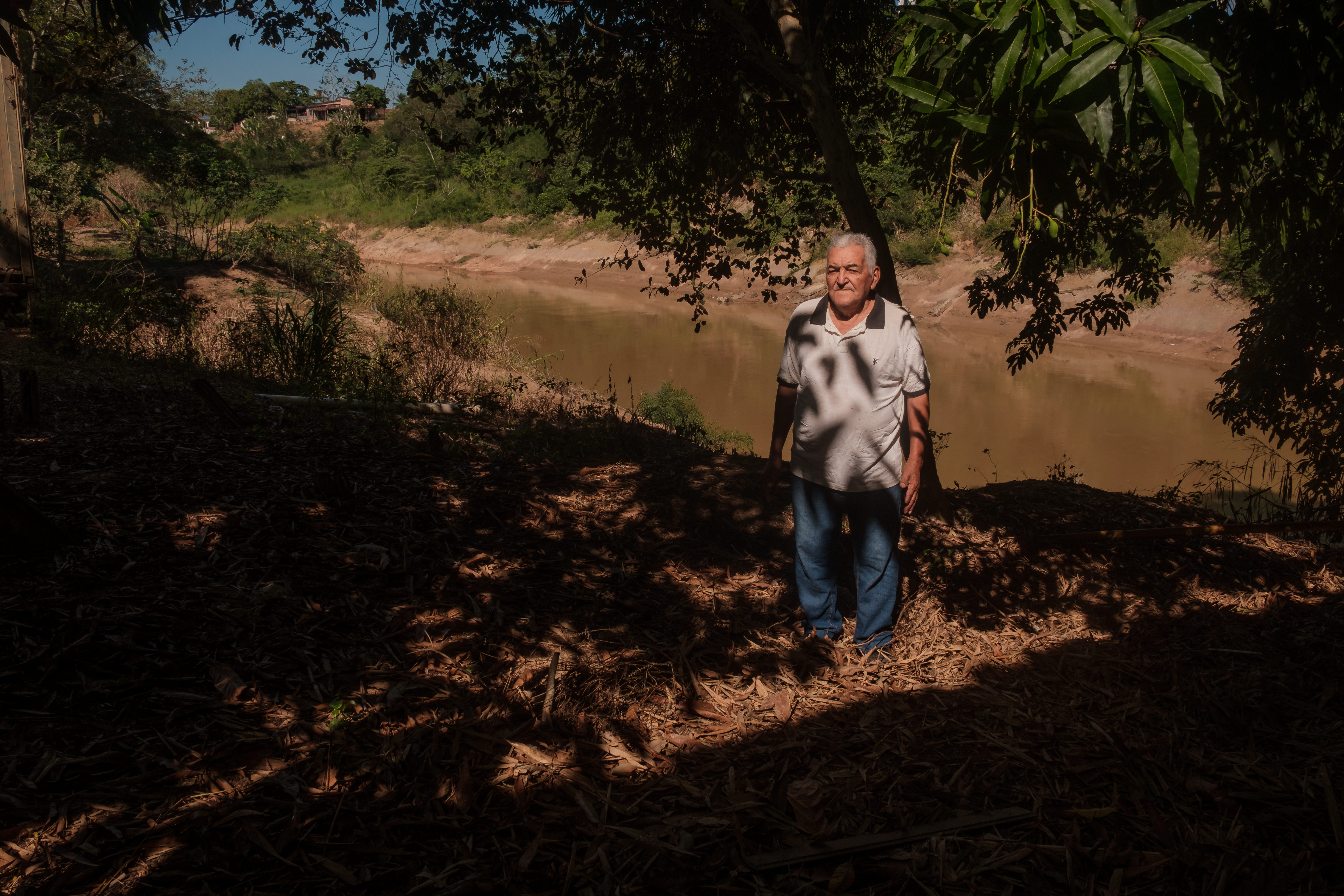
A few metres away, shopkeeper Maria Yzabele Silva shares a similar view. “It used to flood every 10 years. Now, sometimes it floods every two years. You can’t predict it.” The river has always risen and fallen – that is the natural behaviour of the waters. But over the last 15 years, she has seen how floods and droughts have come to occur with ever-increasing intensity and frequency. Maria tries to explain what, in her view, has changed. “It’s quite sad,” she says. “I think it’s pollution, isn’t it? I don’t know… I think people are polluting the river a lot,” she asserts.
The resident’s concern reflects a reality experienced by thousands of people throughout the Acre River basin. Since 2012, major floods have displaced families in various municipalities and, shortly afterwards, have been followed by severe droughts that have affected the water supply, fishing and other activities that depend on the river.
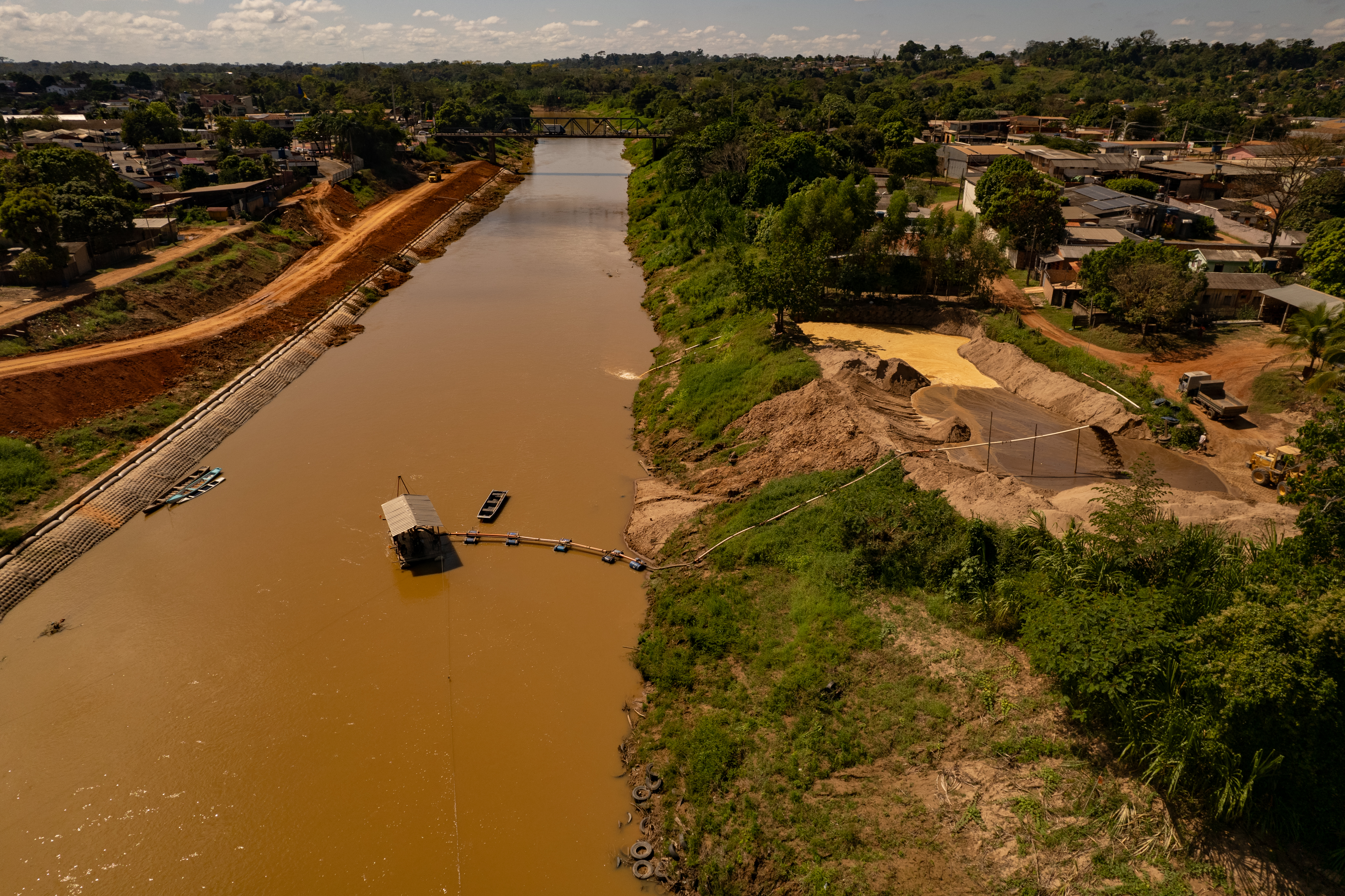
This dependence on the river leaves the capital, Rio Branco, vulnerable to both extremes. During floods, the force of the current can compromise the infrastructure used to collect water; during droughts, the pumps have to operate as water levels drop ever lower. During one of the floods, one of the pontoons supporting the pumps at the Water Treatment Plant (ETA 2) was swept away by the current and became lodged against the Metal Bridge in the centre of the capital of Acre, compromising a large part of the city’s water supply.
In Rio Branco, where there is greater political and media attention, the population has witnessed, over the course of a decade, the River Acre exceed historic flood levels and then reach historically low and critical levels during the drought. But it was not the only one; the Purus and the Juruá, other major rivers in the state, have also undergone the same process. The difference is that the Acre River affects a larger population along its course, as more than half the state’s population lives in the basin and depends directly on its waters.
The former Empreza rubber plantation – formerly a part of Bolivia – became a town and saw its urbanisation accelerate from the 1970s onwards, when thousands of families were driven out of the forest by the so-called ‘paulistas’ – people from the south-east and south of Brazil who migrated to the region – during the process of “bovinization” (transformation into cattle-rearing land) of the Amazon under the military dictatorship. Many families built their homes – or shacks – on the riverbanks in neighbourhoods such as Cidade Nova, Bairro do 15, Baixada da Sobral, Taquari and others; areas that are now classified as high-risk because they are more exposed to flooding and landslides.
Not even the historic centre – from which Rio Branco’s growth has spread – remains unscathed by the river’s movements. The constant and increasingly severe floods and droughts have led to the erosion of tourist spots such as the Calçadão da Gameleira riverwalk and the Old Market, places where – in past decades – large vessels from Manaus and Belém would moor, bringing goods and people to the thriving capital of Acre. On their return journey, they would sail down the river carrying loads of rubber. Today, the river no longer allows this type of navigation. The motorways built in the Amazon during the dictatorship accelerated deforestation and contributed to the collapse of these activities, as well as reducing the river’s use for supply purposes.
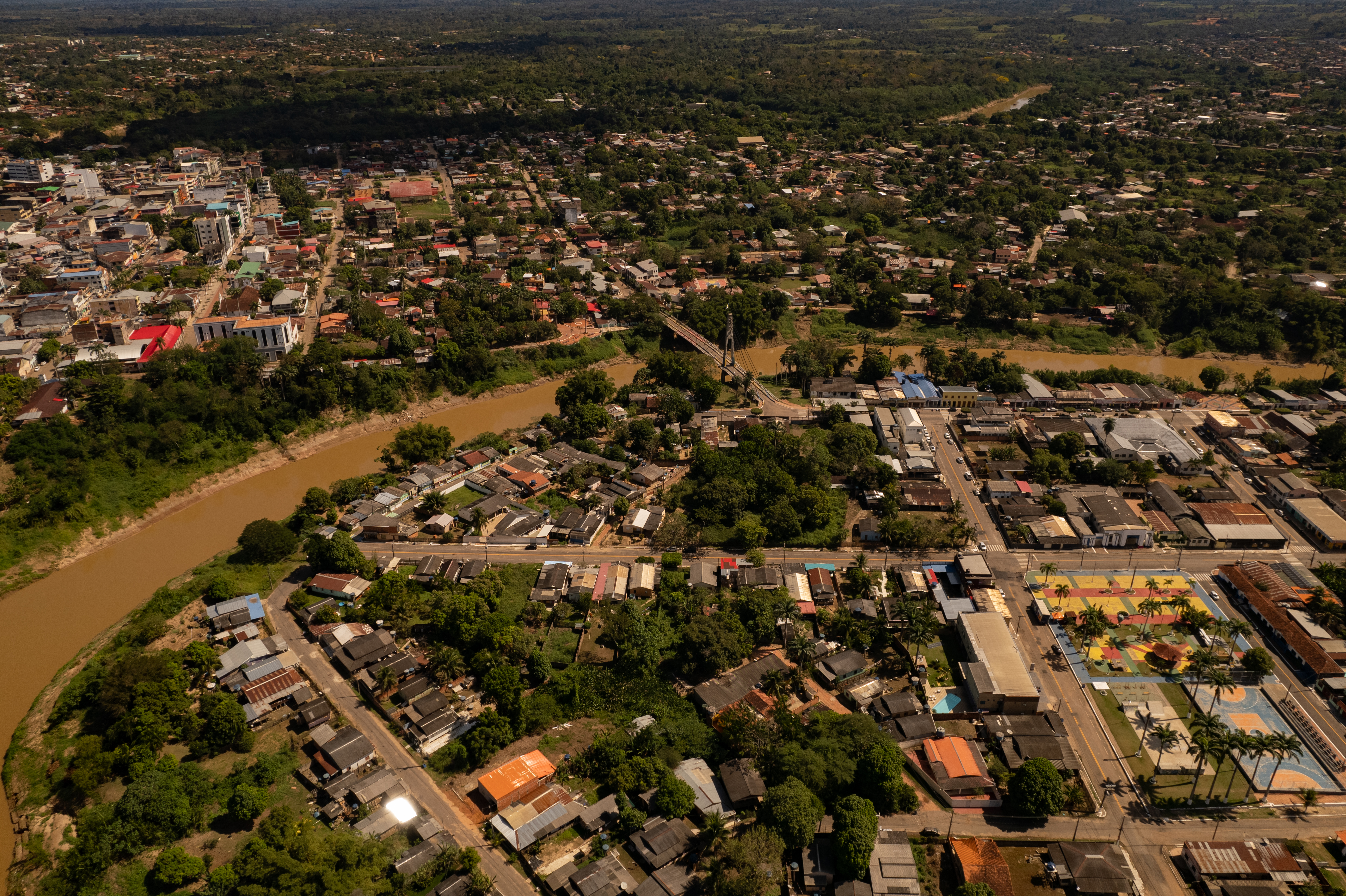
In Rio Branco, the measuring stick installed on the riverbank has become a symbol of daily life: it is by this that many gauge the year, based on the intensity of the floods or the severity of the drought. In the neighbourhoods along the riverbanks, the water marks on the walls give an idea of the severity of the most recent floods. In many neighbourhoods, there is also the phenomenon of ‘fallen land’ – the erosion of the riverbanks caused by the rising and falling of the water – swallowing up houses, shops, streets and the entire history of a city that emerged over a century ago on the banks of the River Acre.
The bridges linking the city’s first and second districts have replaced the old figure of the catraieiro and his catraias (wooden boats), which carried the people of Rios Brancos from one bank to the other and were immortalised in the song by the Acre-born samba musician Da Costa: ‘Catraieiro, row, take me to the other side; boy, hold the oar steady, don’t let the catraia capsize, for I cannot swim.’
An environment that has changed and transformed over the last few decades. On the outskirts of the city, the forest has disappeared. The rubber plantations are gone, replaced by large cattle ranches.
The River Acre is the main source of water for the municipalities of the Acre Valley, home to more than half the state’s population, and forms part of a transboundary basin linking Peru, Bolivia and Brazil. Despite its social, economic and environmental importance, the river has been facing an accelerated process of degradation since the 1970s, caused by the deforestation of riparian forests, the expansion of livestock farming and soybean cultivation, logging and the use of pesticides, which reach its tributaries and compromise the water consumed by the population.
The consequences can extend beyond national borders: droughts and floods affect Brazilian cities and neighbouring towns in Peru. The headwaters of the basin are also under pressure, affecting indigenous territories and areas inhabited by uncontacted peoples. In Acre, four areas officially protect indigenous peoples in voluntary isolation: the Kampa e Isolados of the Envira River, Alto Tarauacá and Riozinho do Alto Envira Indigenous Territories, as well as the Taboca Alto Tarauacá Igarapé (creek), which is subject to restricted use. Together, they cover 636,000 hectares, accounting for 26% of the state’s indigenous lands. In Peru, the departments of Ucayali and Madre de Dios comprise 2.3 million hectares across four reserves designated for these peoples: Madre de Dios, Isconahua, Murunahua and Mashco Piro.
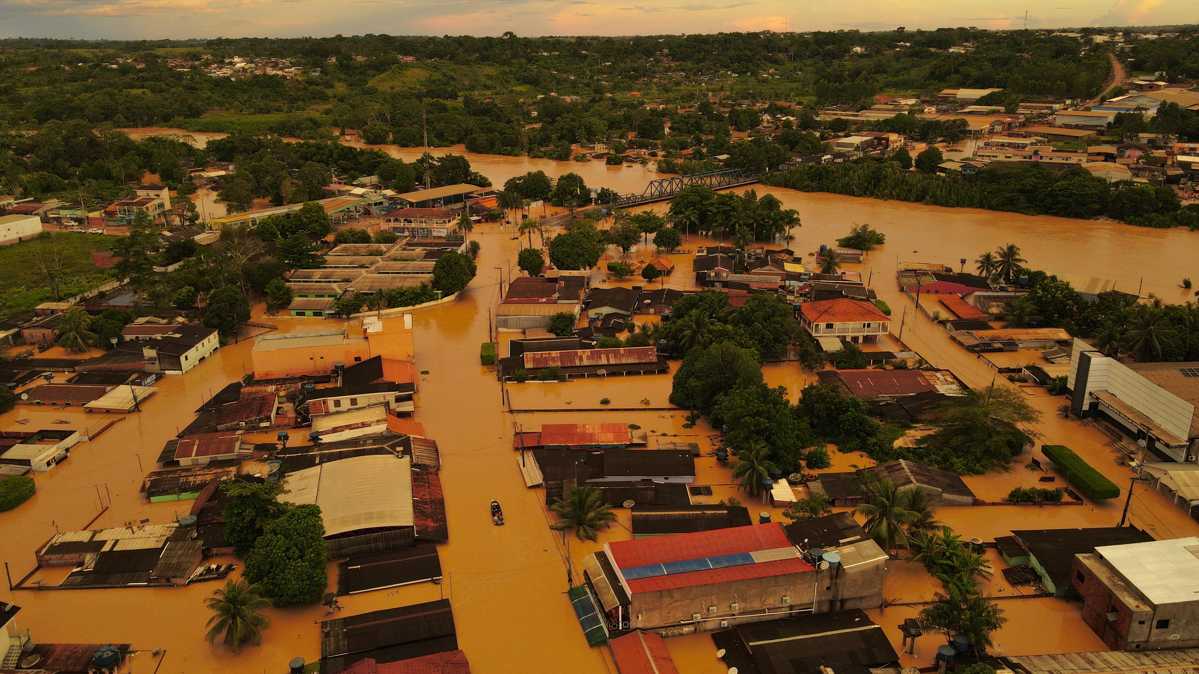
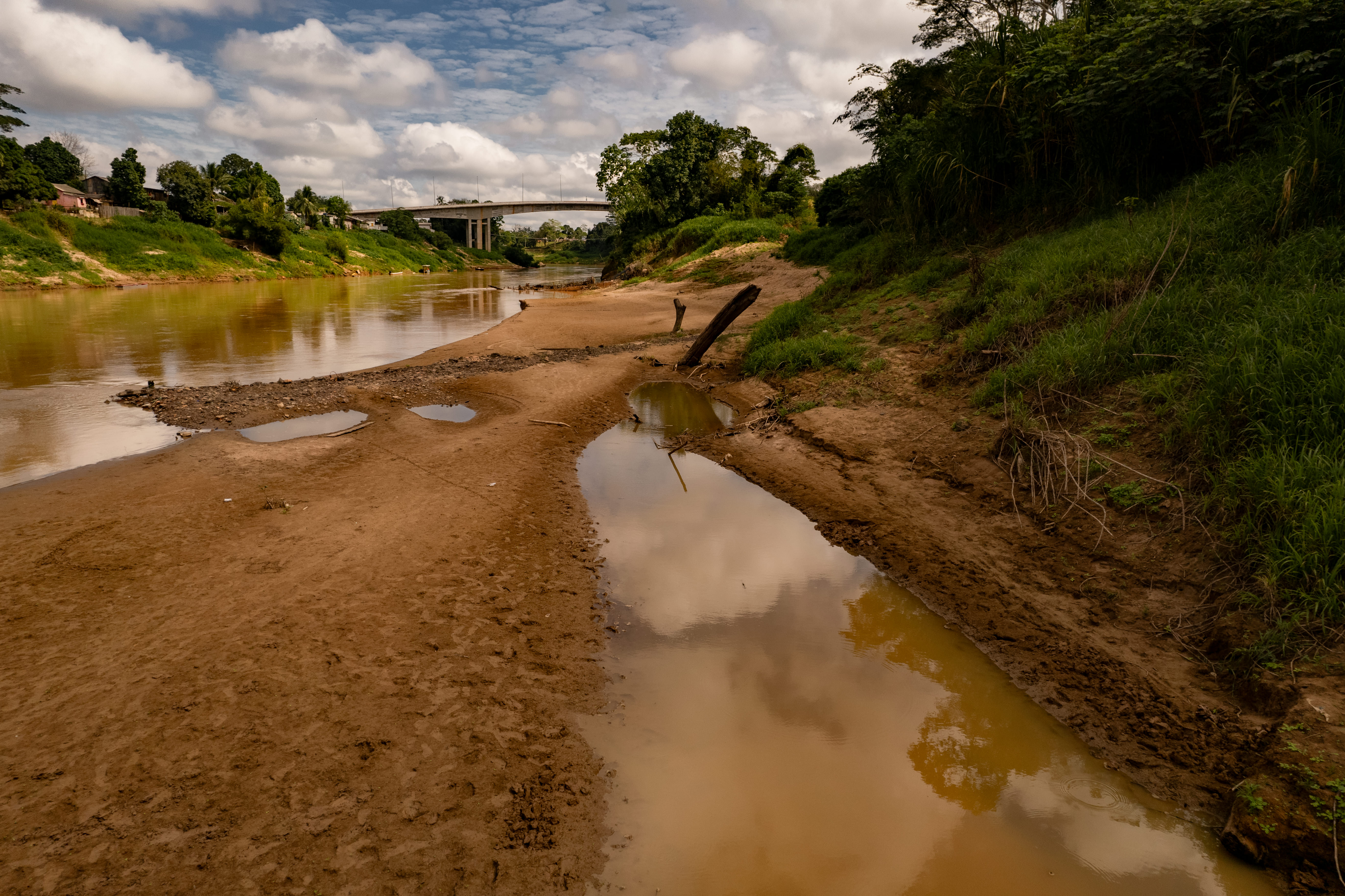
In 2012, the river reached 17.63 metres, then the second-highest level on record, leaving around 90% of the urban area of Brasiléia submerged. The municipality has 26,000 inhabitants – making it the sixth-largest city in the state – and lies on the border with Bolivia, adjacent to the city of Cobija. Three years later, in 2015, it reached 18.40 metres and caused the worst flooding ever recorded in Acre, affecting more than 102,000 people – equivalent to 11.5% of the population, or one in every ten people in the state. In 2023, another flood ranked among the worst in history. A few months later, in September 2024, the river recorded its lowest level since measurements began in 1971: just 1.23 metres.
In just twelve years, the River Acre recorded four of the largest floods in its historical record (2012, 2015, 2023 and 2024), as well as consecutive drought records in 2022 and 2024. And 2024 was a year of extremes, with both drought and flooding occurring within the space of a single year. The succession of these events reveals an increasingly rapid alternation between exceptional floods and severe droughts, causing the basin’s population to live in constant anticipation of the next extreme event.
The River Acre rises in the Amazon region of Madre de Dios, in Peru; it flows through areas of forest, pastureland and rural settlements whilst acting as a boundary between three countries. It enters Brazil via Assis Brasil, on the border with Peru, passes through Brasiléia, Epitaciolândia (on the border with Bolivia) and Xapuri – the birthplace of the famous rubber industry trade union leader and environmentalist Chico Mendes – before reaching the capital of Acre.
It then continues its course until it flows into the Purus River, which runs for 3,382 kilometres before joining the Amazon River, connecting different landscapes, communities and ways of life over a distance of more than a thousand kilometres.
In this story published by Varodouro as part of the Divided Waters project, a collaboration between Latin American journalists and scientists, promoted by Brazil’s Serrapilheira Institute and the Latin American Centre for Investigative Journalism (CLIP), we investigate how the drastic changes to the Acre River are affecting the lives of riverside and urban communities in one of the regions where agriculture is expanding rapidly in the Amazon.
The marks of a changed river
At first glance, the quiet street in Assis Brasil gives no indication of the marks left by the floods that, in recent years, have transformed the daily lives of dozens of families. For Dona Maria das Neves, aged 52, who has lived in the area for two decades, the major floods have shattered a history of seemingly safe coexistence with the river. “When I arrived here, the river was very close to the house and it didn’t flood. Now it dries up more than it used to and floods more than it used to,” she recalls.
According to her, the first major flood occurred in 2012 and took the whole community by surprise. Until then, even though she lived on the riverbank, she had experienced a flood on that scale. With no time to salvage her belongings, she lost building materials, furniture and part of the small shop she ran next to her home. Since then, the arrival of winter — as the local population calls the rainy season in the Amazon — has come to mean fear. “When the year begins, the fear is already overwhelming. We see the water coming and know we could lose everything all over again,” she says.
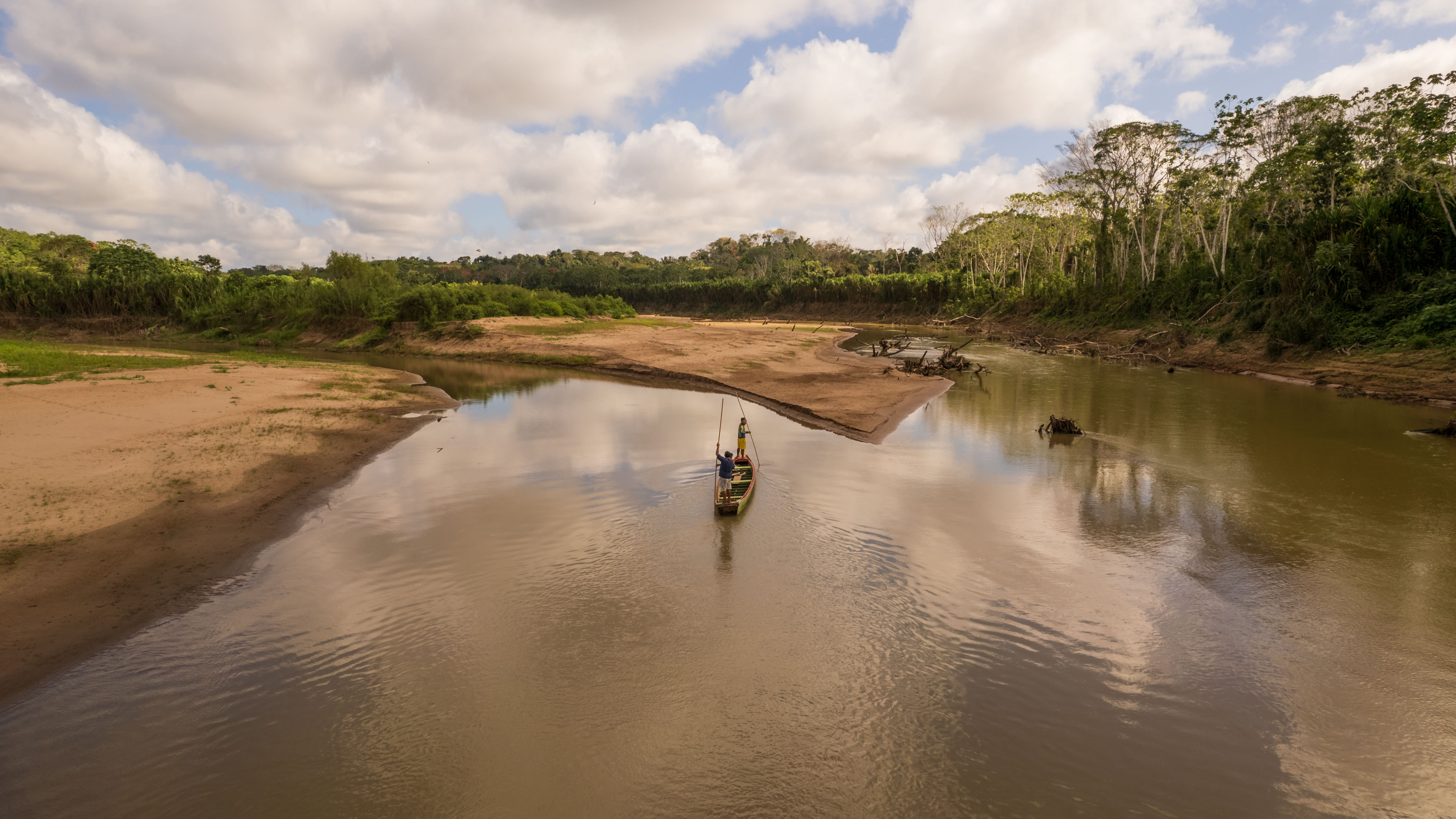
Put simply, the level of the River Acre follows the basin’s rainfall pattern. Periods of heavy rain increase the volume of water reaching the river and can cause it to burst its banks; during prolonged droughts, the flow decreases and the water level can drop to critical levels. This relationship, however, does not depend solely on how much it rains. The way the water reaches the river and circulates through the catchment also influences its behaviour – a relationship we shall return to later. During the most severe droughts, at points near the headwaters on the border with Peru, there are stretches where it is possible to cross the river on foot.
For those living on the banks of the Acre, another noticeable change lies in the rainfall pattern. What for years served as a reference for organising daily life and agricultural production no longer seems so predictable. The first rains of the so-called ‘Amazonian winter’, previously expected between late September and early October, may take longer to arrive, prolonging the dry season.
Dona Maria’s memories reflect these changes. She explains that, when she first arrived in the region, the forest covered a much larger part of the surrounding landscape. Over the years, she has seen the forest give way to open land. “It used to be all forest. Today it’s all open countryside,” she sums up.
In December 2025, the River Acre exceeded the 14-metre flood level in Rio Branco for the first time in 50 years for that month. “In our entire 55-year history of monitoring, we have observed that there has only ever been one instance of the river overflowing in December, on 26 December 1975,” said Lieutenant-Colonel Cláudio Falcão, coordinator of the Municipal Civil Defence, at the time. “We had a similar situation in December 2019, when the river reached 13.78 metres.”
More painful than the material losses was the family tragedy experienced during one of the most recent floods. Whilst trying to save their belongings from the house, Maria das Neves’s husband, who was diabetic, fell ill following the physical exertion and stress caused by the rapidly rising waters. He was taken to hospital, but did not survive. Recalling that moment, she sums up the feeling that remains: “Afterwards, I managed to clean the house and put things back in their place. But he was no longer there. Nothing I could do would bring him back.”

When reflecting on the causes of the changes observed over the years, Dona Maria das Neves links the increase in flooding to deforestation, increasingly intense heat and also human activity. “It used to be all forest. Today it’s all open countryside. The climate has changed so much. Many of the things humans do are wrong,” she says.
In her account, everyday experience is intertwined with faith, which serves as a source of comfort in the face of loss and uncertainty. Her testimony reveals how environmental changes go beyond the physical impacts of the floods and profoundly affect the lives, memories and history of the families living on the riverbanks.
What science already knows about changes to the River Acre
From its headwaters in the Peruvian region of Madre de Dios to its mouth at the River Purus, the River Acre flows through a region that has undergone profound changes in recent decades. Part of its catchment lies within Amacro, a territory comprising 32 municipalities in the states of Amazonas, Acre and Rondônia, which has become one of the main fronts for agricultural expansion in the Brazilian Amazon.
The region is characterised by the expansion of livestock farming and soybean cultivation, deforestation and the use of pesticides. The triple border between the states is also the scene of land disputes, with allegations of land grabbing and human rights violations. Changes in land use are affecting areas close to the rivers and springs that feed the Acre basin.
Hydrological records show that the changes are not limited to the landscape. An analysis carried out by environmental scientist Renan Cassimiro Brito, based on data from the National Water and Basic Sanitation Agency (ANA), found signs of changes in the behaviour of rivers associated with the Amacro region over the last two decades. The survey included 63 flow measurement stations and 102 rainfall stations that met the criteria for data quality and continuity.
Among the stations measuring river flow, 31 – almost half of the 63 analysed – showed a significant downward trend. At a further 19, no statistically significant trend was identified, whilst 13 recorded an increase. The results do not, therefore, point to a uniform pattern across the entire region, but they do show that a reduction in flow is evident at a significant proportion of the monitored sites.
Another indication is the duration of river droughts. The analysis measured the number of consecutive days that flow remained below a threshold considered low for each station, calculated based on its own historical data. At 34 of the 63 stations, the length of time that rivers remained in this condition increased. In the most recent records, these periods exceeded 50 days.
Months were also identified in which the flow was far below the expected levels for that time of year. Over the period analysed, 687 cases were recorded as severe anomalies and 105 as extreme anomalies, with significant concentrations in years such as 2012, 2013, 2014, 2015, 2016, 2018 and 2024.
Rainfall data help to explain part of this behaviour, but do not provide a single explanation. Of the 102 rainfall stations analysed, 33 showed a significant downward trend in precipitation. At the remaining stations, no statistically significant downward trend was identified.
The difference is striking: whilst a reduction in rainfall was observed at around a third of the rainfall stations, a decline in river flow was identified at almost half of the river flow stations. The two networks do not cover exactly the same areas of the country and, for this reason, the comparison does not allow a direct link to be established between rainfall and river flow. Nevertheless, the results show that river behaviour cannot be explained solely by the amount of rainfall.
It is precisely in this region that the landscape has also changed at a rapid pace. Between 2000 and 2024, Amacro lost around 5.2 million hectares of forest cover. The area fell from 39.4 million to 34.2 million hectares. Over the same period, pastureland increased from 2.4 million to 7.6 million hectares – an expansion of nearly 5.2 million hectares – according to data from MapBiomas.
This change occurred across all three parts of Amacro, but to varying degrees. In the Acre section, there was a reduction of around 948,000 hectares of forest cover, whilst pastureland increased by approximately 942,000 hectares. In southern Amazonas, the loss amounted to 1.7 million hectares of forest cover, whilst pastureland expanded by 1.74 million hectares. Rondônia saw the greatest change: there were 2.57 million fewer hectares of forest cover and 2.48 million more hectares of pastureland.
The pressure on the forest is reaching the riverbanks. An analysis carried out by Varadouro, using data from the Brazilian Amazon Forest Satellite Monitoring Programme (Prodes) run by the National Institute for Space Research (INPE), indicates that around 4,500 of the 11,670 hectares of riparian forest along the River Acre within the state have already been destroyed, equivalent to approximately 40% of the total. The loss has not been uniform across the basin. In Epitaciolândia, it reached 58%; in Rio Branco, 43%; in Capixaba, 35%; in Xapuri, 33%; and in Porto Acre, 32%.
Between 2008 and 2023, a further 141.2 square kilometres of native vegetation were cleared within a strip of up to one kilometre from the riverbanks, and half of this loss occurred after 2018.
Researcher and agronomist Evandro Ferreira, who holds a PhD in Botanical Sciences from the City University of New York and is affiliated with the National Institute for Amazonian Research (INPA) and the Federal University of Acre (UFAC), explains that the removal of vegetation from the riverbanks leaves the soil more exposed to erosion. When it rains, some of this material is washed into watercourses, increasing the amount of sediment and contributing to silting. As sediment accumulates, sections of the riverbed can become shallower.
Signs of degradation in the catchment were already a cause for concern amongst researchers before the most recent succession of record floods and droughts. In an article originally published in 2014 and updated ten years later, Ferreira warned of the risk of water scarcity in eastern Acre. This part of the state accounts for around 70% of the deforestation recorded in Acre, although it covers only 22.5% of the state’s territory. It is also in this region that the Acre River basin is located, which drains approximately 90% of the eastern part of the state and in whose catchment area around 500,000 people live.
The data, however, do not allow the conclusion that deforestation is responsible for the extreme floods or droughts recorded in recent years. The hydrological analysis identifies trends and anomalies, but does not determine their causes. Similarly, the reduction in forest cover and the expansion of pastureland occurred in the same territory and during the same period, but this coincidence is not sufficient to establish a cause-and-effect relationship.
What emerges from the various surveys is a region undergoing transformation. Some rivers are experiencing reduced flow; periods of low flow are lasting longer at dozens of gauging stations; and severe and extreme events appear repeatedly in the historical records. At the same time, millions of hectares of forest cover have disappeared and pastureland has encroached upon the Amacro basin.
The question that remains is how much of these changes in water behaviour is related to climate change and how much may be linked to transformations occurring within the catchment itself.
According to the researchers, forest fragmentation alters fundamental processes of the hydrological cycle. Vegetation acts as a natural infrastructure: it intercepts some of the rainfall, promotes water infiltration into the soil and gradually releases this water into the rivers. With the loss of this cover, water tends to run off more quickly during rainfall and remains available in the system for a shorter time during dry periods. Recurring fires reinforce this process by degrading the soil and reducing its water-retention capacity.
“The data do not allow us to establish a direct cause-and-effect relationship between deforestation and specific flood or drought events. But they show that we are observing simultaneous changes in land use, rainfall patterns and key hydrological indicators,” says Renan Cassimiro Brito, an environmental scientist and PhD candidate in physical geography at the University of São Paulo (USP), who is also a member of Serrapilheira’s quantitative ecology training programme. “The scientific challenge is to understand to what extent these processes are connected.”
Click here to download the full methodology of the analysis
The cross-border nature of the catchment amplifies this challenge. Some of the changes are taking place in the headwaters of the River Acre, in Peruvian territory, which requires analysing the catchment as a single system.
“Rivers do not recognise political borders. What happens at the headwaters can have repercussions hundreds of kilometres downstream. That is why it is essential to look at the entire basin and not just the stretch of the river that lies within Brazil,” explains Natale Dias, a biologist at the Federal University of Paraná (UFPR) and also a participant in the Serrapilheira Institute’s programme.
This connection became evident during the floods of 2024. In February, the River Acre reached 15.83 metres in Cobija, Bolivia – a record high at the time – affecting more than 2,300 people, 15 to 18 neighbourhoods and three rural communities. On the other side of the border, in Acre, Brasiléia was also inundated, leaving around 75% of the municipality cut off.
The recurrence of flooding has led Bolivian authorities to discuss flood defences along the riverbank at Cobija, located directly opposite Brasiléia, whilst experts and authorities in Acre have begun to question what effects an intervention on one side of the border might have on the other.
The instability of the water levels also affects farmland, as in 2023, when riverside farmers in the rural area of Rio Branco lost their crops and livestock during the floods. Months later, they faced the exact opposite: a severe drought, accompanied by high temperatures, which damaged banana, cassava and maize crops. Some families became dependent on water tankers to obtain drinking water. Before they had time to fully recover what had been lost, a new flood struck the region in early 2024.
Experience that goes beyond the data
Antônio Chaves, aged 82, does not need to refer to data to say that he has noticed changes, as he remembers the cold spells that lasted a week or more, the riverbanks that gradually gave way under the force of the water, and the floods that began to reach places previously spared. In Brasiléia, he points to the spot where his house once stood, destroyed by the 2023 flood.
For those who live by the river, the consequences are more immediate. Floods mean moving furniture out, leaving one’s home, losing crops and waiting for the water to recede. During the dry season, other problems arise: water shortages, difficulties in farming and an ever-lower river level. In recent years, many of these families have had little time to recover from one extreme before the next one strikes.
Antônio is familiar with this cycle. After the 2023 flood, he returned to the place where he had built his life and found a different landscape. The house is no more. Before him lies the River Acre. A river of extremes.

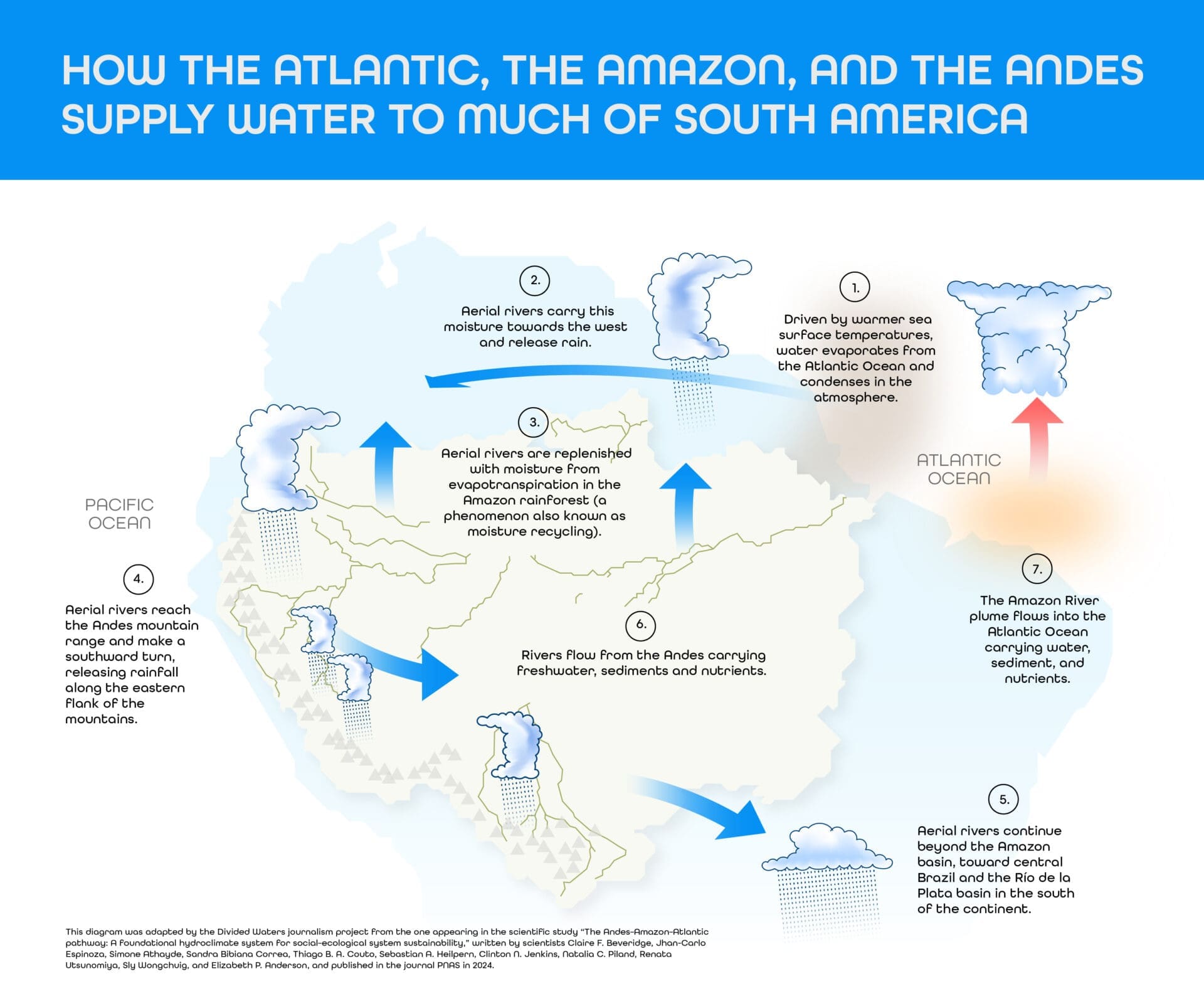
This project is the result of a collaboration between Latin American journalists and scientists, spearheaded by Brazil’s Serrapilheira Institute and the Latin American Center for Investigative Journalism (CLIP), to explore the Atlantic-Amazon-Andes water pathway and the disruptions to the ecosystem services it provides to the continent.


