

- In the Harakmbut community of Arazaire, where gold mining diverted the course of the River Inambari, satellite imagery shows a larger water surface area than twenty years ago, but community members say this is water they can no longer drink or fish in. After generations of having safe drinking water, they have had to buy it for the past few years.
- A satellite analysis of 84 micro-basins of the Madre de Dios River, many of which are located within indigenous territories, shows that between 2000 and 2023, nearly 13,000 hectares of artificial water bodies appeared that did not previously exist. These are the pools left behind by mining operations.
- Two out of every three indigenous communities in Madre de Dios have to buy water.
Por: Vanessa Romo Espinoza/ Mongabay Latam
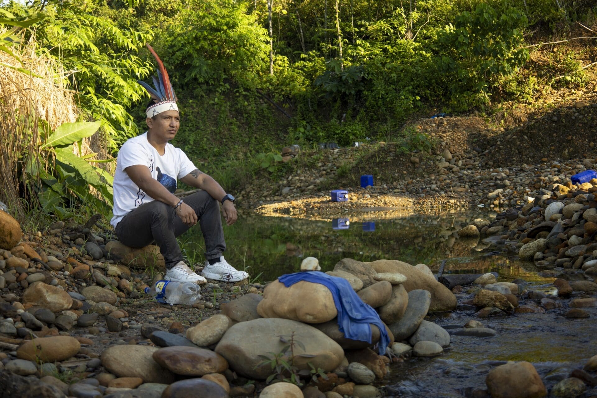
“People think that because we live in the jungle, we have plenty of water. But this is the reality,” Erick Aguirre Tijé, a Harakmbut indigenous resident of the southern Peruvian Amazon, is quick to point out, as he points his index finger at the murky water flowing down the Inambari River. Erick bears the surname of the family that founded the Arazaire indigenous community on the river’s banks – one of the rivers that feed into the Madre de Dios basin and, ultimately, the great Amazon – and has witnessed how that territory has been changing since 2010.
He recalls, for example, that five years ago it was common to see the ‘peque-peque’ traditional wooden boats ploughing through the river carrying people, as well as the nets landing on the water to fish for sabalo and zúngaros (a type of catfish). He also recalls families enjoying watching their children swim, women coming down to fetch water, or men sunbathing to shake off their tiredness. That picture has changed and is now a fairy tale for his cousin Santiago, who is the same five years old as the time that has passed since that ‘new normal’ began.
To reach the Inambari, you have to clear a path. Erick Aguirre, accompanied by little Santiago, makes his way forward, machete in hand, cutting through the vines that have grown after a year of not visiting the area. “We don’t use the river anymore,” he says with a whiff of resignation. A kilometre away, you can hear its roar. It remains present in their lives, though it is no longer part of them. All that remains is the memory of that river which, more than 50 years ago, captivated his grandfather José Tije and convinced him to settle his Harakmbut people there.
Elda Gutiérrez, Santiago’s mother, asks him not to drink water from the river or the streams during the walk. She suggests he take a bottle of water they have bought instead. “Until five years ago, we could walk more than 3 kilometres to the Buenqueme stream,” says Ruth Tijé, a resident of Arazaire, describing one of the spots they used to stop for a drink. She is referring to a water channel visible from the Interoceanic Highway, which was built between southern Peru and the Brazilian state of Acre and runs very close to the community. “Now it’s nothing but mining sludge,” says the indigenous leader.

In Arazaire and the other communities settled along the Inambari, the murkiness of the water is attributed to mining. It’s responsible for the pollution, for the change in the river’s course due to the amount of sediment removed during the extraction of golf, and also for the diversion of the river to facilitate the work of illegal miners operating on the opposite bank. Erosion, they say, is mercilessly devouring indigenous lands.
“The territory of Arazaire is getting smaller and smaller because the river’s flow has eroded the community’s land,” adds Tijé. “It’s already taken away about 300 to 500 metres. The river used to be far away; now it’s close by.” This proximity does not work in their favour, not only because of the risk of flooding but also because they can no longer make use of that mud-laden water. The data confirms their fears. An analysis carried out by Mongabay Latam, using Google Earth, confirms that 13.5 hectares were swept away between 2012 and 2025.
This led them to seek out other sources of clean water, such as the Buenqueme stream. Before long, the villagers recount, water there also began to run dirty, and they had to go further afield, to other streams, in search of clean water. But mining pollution caught up with them there too.
“What happens upstream affects us downstream,” says Ruth Tijé, summing up the problem.
On Google Earth, you can see how the river’s course has changed over time and how the landscape has evolved. This has had a negative impact on the community of Arazaire. Image: Google Earth Timelapse
How can we make sense of the paradox of a community that lives surrounded by water but cannot use it? How much has the Inambari River and the entire Madre de Dios basin changed in recent years? Satellite images reveal this contradiction: an area with more water surface area than twenty years ago, but one that has expanded because of mining-related ponds and patches of deforestation.
Journalists from Mongabay Latam, El Espectador and Correo del Caroní analysed the changes that have affected the Madre de Dios over the last two decades, as well as three other Amazonian rivers, with support from scientists at MapBiomas and the quantitative ecology training programme at Brazil’s Serrapilheira Institute. They carried out this work as part of the ‘Divided Waters’ investigation, coordinated by the Latin American Centre for Investigative Journalism (CLIP) in partnership with eight media organisations across the region.
In total, this journalistic alliance analyzed 722 micro-watersheds in four countries—63% of which are territories of at least 74 indigenous peoples—using the micro-watershed analysis by the Amazon Network for Georeferenced Socio-Environmental Information (RAISG), based on data from the MapBiomas Agua platform. The results are striking. In Bolivia, micro-watersheds with illegal mining saw their water surface area increase by 21.5% over 25 years, while those without any illegal mining lost 17.2%. In Venezuela, the total water volume of the 98 tributaries and reservoirs along the Caroní River fell by 5.8%, according to data from MapBiomas Venezuela. Since more than three-quarters of the Caroní’s water is contained by three large hydroelectric power plants (Guri, Macagua, and Caruachi), this fact masks a significantly larger loss of water in the rivers. In Colombia, where deforestation driven by cattle ranching is the dominant pressure, there are micro-basins where cumulative deforestation covers more than half the territory, and the most heavily deforested areas are also losing water. And across all four watersheds, a more nuanced pattern emerges: one in six micro-watersheds loses natural water and gains artificial water at the same time, in the same location; of every five hectares of that artificial water, more than four are located on indigenous territory.
In the Peruvian case, in the Madre de Dios catchment, 84 of the 155 micro-catchments that make it up were analysed. In 45 of these, an increase in artificial water has been recorded, and almost all of this new water is concentrated in the micro-catchments where both legal and illegal mining takes place: between 2000 and 2023, the area of artificial water in the catchment increased almost twelvefold — from 1,224 to 14,418 hectares — and 99.7 per cent of that water is in the 45 micro-catchments where mining is registered; in the 39 where it is not, it barely reaches 38 hectares. Just three micro-basins — including that of Arazaire, on the River Inambari — account for 81% of all this new water. Furthermore, 41 of these 84 micro-basins overlap with the indigenous territories of 14 different communities: it is not that there is more water, but rather that pools have appeared where there was previously nothing, and a large proportion of them are on indigenous territory.
In these micro-basins, illegal mining occupies an average of 10.3% of the territory, compared with just 0.4% where there is no indigenous territory involved, according to the scientific analysis carried out for this investigation. And the more indigenous territory a micro-basin contains, the more anthropogenic water it records, according to the project’s statistical model. The communities are not protected from mining; rather, they are surrounded by it.
It is precisely because of these pools that Arazaire stands out: an indigenous community overrun by backhoes, dredges and pollution, where the Peruvian state has granted 11 registered and active mining concessions that overlap with Arazaire’s territory. And there are 153 such concessions affecting eight indigenous communities in Madre de Dios, covering 12,768 hectares of communal territory, according to an investigation published in March 2026 by Mongabay Latam. Amazon Mining Watch, a platform that tracks mining in the Amazon using artificial intelligence to analyse satellite imagery, reveals the extent of the damage within the community’s own territory. By mid-2026, mining is estimated to have affected 688 hectares within this territory, a figure that has risen since 2018, according to the platform’s data. Furthermore, it is estimated that 85 per cent of this activity takes place outside any concession, in areas where mining is unauthorised. In other words, most of the mining that is eroding Arazaire is presumed to be illegal.
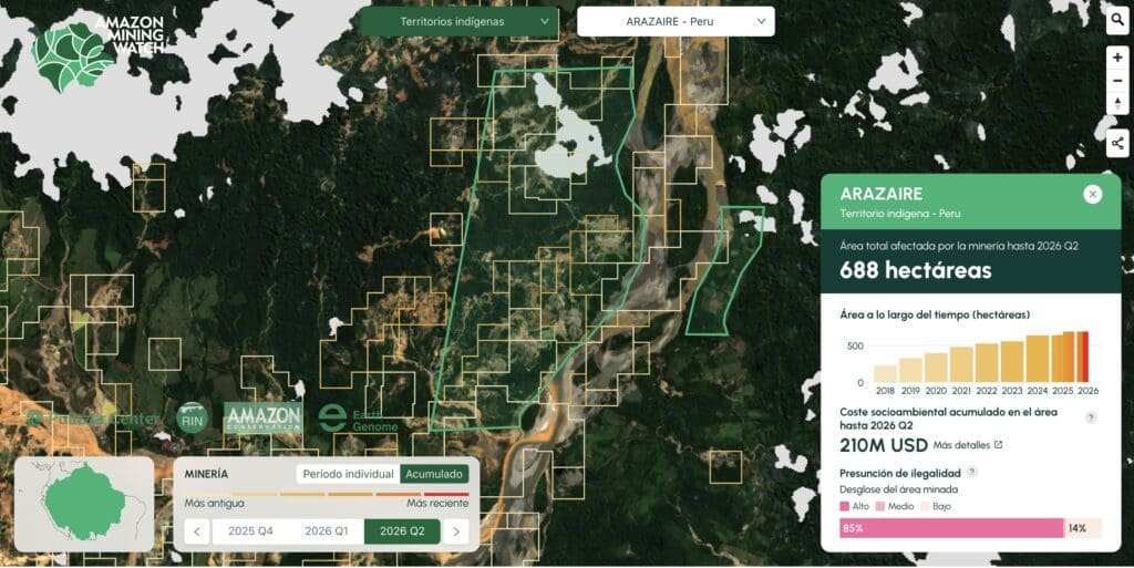
The underlying issue is a legal one. According to César Ipenza, an environmental lawyer and spokesperson for the Observatory on Illegal Mining, there is no explicit ban preventing the State from granting concessions over bodies of water. It authorises them on the grounds that the title is not an exploitation permit, as additional environmental permits are required for that. The legal problem lies in the fact that concessions for bodies of water are applied for to reserve the subsoil, but in practice they are used as a shield to gain entry into the Reinfo. The Comprehensive Mining Formalisation Register (Reinfo) is a register created in 2016 to regularise small-scale miners, granting them exemption from criminal liability whilst the process is ongoing; the deadline for this has been postponed five times over the past ten years. This makes it easier to operate without permits and to use the mining title to mislead communities, whilst banned dredges continue to operate on the rivers.
“The miners take indigenous communities by surprise, as they use the concession title to claim that the state granted them that right,” he explains in the same Mongabay Latam investigation. Added to this is the fact that dredges – the machinery used to extract gold from riverbeds – have been banned in rivers since 2012, and yet they continue to operate within the Inambari’s titled concessions.
Arazaire has already experienced this legal loophole first-hand. In 2025, members of the community found an excavator operating within their titled territory; they stopped it and reported it to the Specialised Environmental Prosecutor’s Office (FEMA) in Madre de Dios. A few days later, the state ordered that it be returned. “The 200,000 soles (60,000 dollars) that machine is worth cost more than our lives,” summarise the community leaders, who prefer not to be named for safety reasons. What happened next in that case would ultimately show which way the balance tilts.
The water they cannot drink
In Arazaire, water is bought. The Native Federation of the Madre de Dios River and its Tributaries (Fenamad), which brings together 38 communities from seven indigenous peoples in the region, confirmed to Mongabay Latam that two-thirds of those 38 indigenous settlements in the region pay for their water.
“It won’t be long before water costs more than oil,” says Eusebio Ríos, vice-president of Fenamad and leader of the Harakmbut people.

According to residents who rely on this service, each tank holds 1,100 litres and costs 70 soles (around $21), although there are also 20-litre jerrycans for which they pay 11 soles (around $3). “You have to ring the local council religiously to have the tank filled once a week,” says Elda Gutiérrez resignedly.
The image of the mud that displaced the crystal-clear waters of the Inambari remains etched in the memories and conversations of the villagers living on the banks of this tributary. Eusebio Ríos still recalls an idyllic childhood in which the river was the centre of his life. “As children, we used to dive and watch the fish; it was wonderful. Now we are faced with this outrage and the risk of extermination, because we can no longer drink the water from either the rivers or the streams. They are polluted by mining,” he says.
An analysis carried out by a team of scientists from the Serrapilheira Institute — with advice from experts at MapBiomas Agua — confirms this. Between 2000 and 2023, around 13,000 hectares of artificial or anthropogenic water bodies appeared in various sections of the Madre de Dios catchment area; this is another way of referring to the contaminated ponds left behind by mining. In 2000, artificial water bodies accounted for barely 1% of the area analysed. Two decades later, by 2023, this figure had risen to 11%.
In other words, today, one out of every nine hectares of water detected in the area corresponds to mining-related ponds. Sentinel-2 satellite images show that the most affected areas are precisely those where some communities claim they cannot use the water, a fact confirmed by Fenamad leaders.
This increase is more pronounced in the territories of the Harakmbut people themselves – the community to which Erick, Ruth and Marcia Tijé belong – which collectively account for more than 12,000 hectares of new anthropogenic water, more than all the other identified communities in the basin combined.
These findings are consistent with what science has already documented for Madre de Dios. A study published in 2020 by scientists from Duke University and the Centre for Amazonian Scientific Innovation (Cincia) measured the expansion of artificial ponds and lakes created by gold mining using satellite imagery from 1985 to 2018. They found that in the most heavily mined catchments, the surface area of these bodies of water grew by 670%, whilst in catchments without mining the increase was just 20%. They also found that these pools convert mercury into methylmercury – its most toxic form – at a rate up to seven times faster than rivers. Although rivers also carry out this conversion naturally, the stagnant, oxygen-depleted water in the pools drastically accelerates the process. In other words, the new water that appears is not only unusable, it is more dangerous than the water it replaced.
What this research analysis contributes is more up-to-date, covering the period up to 2024, and on a different scale: not just the Madre de Dios basin, but four basins across four countries, all showing the same patterns: the Caroní basin in Venezuela, the Beni basin in Bolivia and the Caquetá basin in Colombia.
Carlos Álvarez, an indigenous guardian from Arazaire, points to one of the pools within the communal territory. At first glance, it looks like a hollow containing stagnant, dark brown water.
“We used to fish for bocachico (black prochilodus), sábalo and huasaco (wolf fish) there,” he says.
“And what’s in that water now?”
“Just mud. There’s no life left; there’s nothing.”

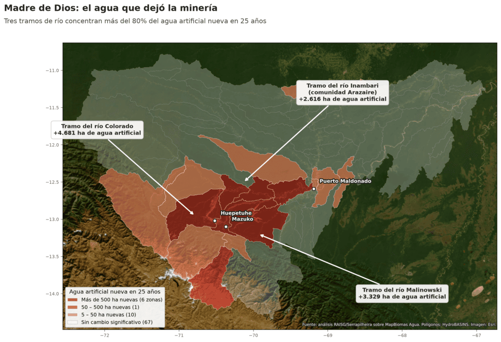
In 23 years, the area of artificial water bodies in Madre de Dios has increased almost twelvefold. It has grown from 1,224 hectares to 14,418, according to data compiled by MapBiomas. However, this growth has not occurred throughout the entire catchment area, but only where machinery is present. More than 99% is located in rivers where the satellite has detected mining activity. In other words, almost all of the new artificial water is concentrated in 45 of the 84 micro-basins analysed. This amounts to more than 13,000 hectares, 40% of the total area of the Machu Picchu Historical Sanctuary. In the remaining 39, where no mining activity has been recorded, the artificial water covers a mere 38 hectares.
Most of the artificial water detected – over 80%– is concentrated primarily in three micro-basins located along sections of the Colorado, Malinowski and Inambari rivers. In the community of Arazaire, which lies on the banks of the Inambari – now one of the three rivers – one in every five hectares of water is artificial.
That specific section of the Inambari, which flows through Arazaire, covers an area of more than 164,000 hectares and is one of the hardest-hit areas in Madre de Dios. It has the highest proportion of land under mining concessions (81% of the territory), ranks second in terms of forest loss, third in the number of artificial water bodies, and sixth in the volume of mining activity detected. In fact, the area of artificial water bodies in that stretch has increased by some 2,615 hectares over 23 years.
“That area, which used to be nothing but trees, is now nothing but ponds. There are bodies of water that weren’t there before. The little streams that used to be there are now filled with tailings,” says Ruth Tijé, referring to what is happening in that area on the left bank of the indigenous territory.
Although the satellite can detect changes in the water surface, certain details may be overlooked. Joaquín Romualdo, a geographer specialising in remote sensing at the Instituto del Bien Común and head of water analysis for MapBiomas in Peru, explains it this way: “We capture the data as an aerial photograph, but if the river level drops, we cannot detect that, let alone the pollution.” In other words, if the river’s level drops or it becomes filled with sediment and mercury, that degradation is not recorded.
That is why a community may appear on maps surrounded by more water than ever, when on the ground it is already forced to live with its back to the river. “Water suffers the most; it is the element that suffers the most in the end, alongside the forest,” adds Romualdo.
Arazaire, for example, is hemmed in by mining and the deforestation it brings in its wake. This is one of the points most highlighted by the analysis and a story whose full impact can only be told from within the territory itself.
Maps against oblivion
A group of community members unfolds a map on the table. They are gathered outside the maloca at the Arazaire community centre – the ceremonial hall with a thatched roof and earthen floor where the inhabitants meet to make their most important decisions. Together, they examine the community’s territory on a satellite image shared with them by the Mongabay Latam team. It is their land seen from above, as they have rarely seen it before. Coloured markers are scattered across the table, and they are invited to point out their main water sources, the routes they used to take to reach the river, and the streams they used to visit but can no longer return to.

Beatriz Tijé’s index finger begins to trace the route of the Interoceanic Highway on the map. She is the one who pinpoints the turning point. “From 2012 onwards, the [mining] machinery came in force here,” she says. It was two years after that road opened, reducing the journey time from her community to regional capital Puerto Maldonado from a full day to two and a half hours. The same road that brought in the miners and deforestation just as easily.
Forest loss due to mining in Madre de Dios rose by more than 400% following the arrival of that road, according to Cincia, a renowned environmental NGO which, amongst other activities, has been monitoring mercury pollution in the Amazonian rivers. This link is confirmed by the figures for the entire basin: deforestation is the pressure most closely associated with the emergence of artificial water bodies across all four watersheds—because logging often goes hand in hand with mining, which is what creates the pools. The loss of natural water, on the other hand, is not due to a single pressure.
Marcia Tijé agrees with Beatriz and begins to list what the water has taken away. “We used to go up to Amanatapo, which was a lake. My dad and I would always go there to fish, with a spear, right up until the very end,” she says, pointing to a spot they can no longer return to. They went from hunting and fishing in the river to running fish farms and buying food in Mazuko, the largest town, 20 minutes from the community. “Before, there was more bartering. We’d grow crops – plantains, cassava – and sometimes swap them for meat, cassava, pineapple or oranges that a neighbour had,” says Ruth Tijé. In a very obvious and dramatic way, the landscape changed with the arrival of heavy machinery. Satellite images merely confirm what the Tijé sisters already know by heart.
Marcia Tijé is the one who preserves the stories of the Harakmbut in her community. She learnt this from her father, the patriarch who founded Arazaire. Many of these myths are used to address the major doubts some people have about the reasons why, according to the community, landslides are responsible for the deaths of some miners.
“That was the ‘siquitbe’,” replies Marcia Tijé without hesitation. For the Harakmbut, the ‘siquitbe’ is a sort of five-headed dragon that lives beneath the forest. “It’s located along the stretch between kilometres 65 and 125 of the Interoceanic Highway,” she explains. It is a guardian of the forest that lies dormant, but which can be awakened. “When they draw water from the pools, when they dig too much, they rouse the beast. Years ago, there was a massive flood in one of the mining areas and it swept everything away – the mining area, the bars, the prostitution. All that was left was stone, sand and sticks,” says Marcia. That is why she believes the ‘siquitbe’ won’t be long in reappearing. “If they carry on digging for gold, it’s going to flood everything again and sweep everything away once more.”

The community’s collective memory goes hand in hand with what is undeniable: mining is encroaching more fiercely than the ‘siquitbe’. This is evident simply by looking at Arazaire and its history. When the Peruvian state granted them title to the land in 1976 – several decades after they had settled there – two distinct geographical areas were created, divided by the Inambari River and its tributaries. On the right-hand side are the houses, the chacras (or farmland) and the fish farms. And on the left are the headwaters of the streams that feed the Inambari, where they used to hunt and perform rituals. “Nobody worked there. Everything was green. They would go hunting, to gather fibre and seeds,” adds Ruth Tijé. Now that area is occupied by legal mining – that is, land granted to concession holders or private companies – and by illegal mining, as detected on platforms such as Amazon Mining Watch, where mining activity can be seen outside the areas designated as concessions.
Arazaire’s struggle against the concessions did not begin with this generation. Its founder, the Harakmbut leader José Tijé Huarao, asked the state to annul the concessions that had been encroaching on the community since 1991. The response came eight years later, in 1999. The request was dismissed, because in such proceedings only the concession holder and the state may participate, without the involvement of third parties. Not even the community itself, on whose land the permits were granted, had the right to have its say. José Tijé died on 14 July 2020, aged 81, from Covid. Two days later, on 16 July, the Ministry of Energy and Mines issued formal notices to some of the miners operating within the community he had founded.
Erick Aguirre Tijé is also sitting around the table. He listens attentively to his colleagues, whilst the map begins to activate his memory. He explains that to reach the main flow of the Inambari, he simply had to cross narrow streams running alongside the right bank of the Arazaire. “We could even cross them on foot,” he says. But between 2010 and 2012, that narrow tributary of the Inambari, where they used to fish and bathe in peace, became a fast-flowing branch of the river. “They diverted it upstream so that it wouldn’t damage the mining area,” explains Marcia Tijé. That “mining area”, situated on the left bank of the Arazaire, was a sacred site for the community.
The images on Google Earth, spanning from 1980 to 2010, provide a timeline for the changes described by the residents of Arazaire. In 2010, for example, the stream running along the right-hand side of the community can be seen to have been narrow. Two years later, in 2012, images taken upstream of Arazaire show how the river’s flow had begun to change and a section of the community had started to erode. Satellite images from 2025 confirm that this erosion now extends to cover some 13,5 hectares.
Marta Torres, national director of Cincia, points out that this type of change in the river’s course is often observed when there is illegal mining upstream. “That silt [from mining activity], as it moves downstream, begins to settle. This means that the riverbed becomes silted up, the channels fill up and lose depth. As the depth decreases, the risk of flooding increases. We are experiencing increasingly severe floods. And in the dry season, that large amount of silt found on the riverbed is now visible as sandbanks, and these begin to alter the course of the river,” she explains.
The floods took their heaviest toll on Arazaire seven years ago. “The worst period of flooding was between 2019 and 2020 – a catastrophe,” recalls Marcia. The water rose to over three metres, she adds, reaching the fish farms where pacos (Piaractus brachypomus) and gamitanas (Colossoma macropomum) were being reared, and sweeping away everything in its path. “Fish farms, cocoa and plantains were all lost,” she adds. And when it’s not the floods, it’s the droughts, which are drying up the river and streams “more than before”.
This fluctuation, between too much water and too little, is not just a local phenomenon. Data from MapBiomas Água show that, across the Peruvian Amazon, the wet and dry seasons are becoming increasingly extreme – part of what scientists call the intensification of the hydrological cycle. In 2000, for example, satellite images showed that the area covered by the Inambari River was around 20,000 hectares. By 2025, that area had expanded to 30,000 hectares. “It is a direct consequence of climate change. The wet months are becoming wetter, and the dry months drier,” explains Joaquín Romualdo of MapBiomas Agua Perú. Furthermore, since 2019, the water surface area of the Amazon has been decreasing year on year, reaching a critical point in 2024. In 2025, there was a slight recovery, but levels did not return to what they had been before.
At the same time, what is happening on the left bank of the community is another tragedy. According to the Global Nature Watch platform, between 2001 and 2025, 530 hectares of forest were lost – almost half of the vegetation that existed in that area.
Waldo Lavado-Casimiro, deputy director of applied hydrology at the National Meteorological and Hydrological Service (Senamhi), acknowledges the impact of the climate, but clarifies that in a region so heavily affected by mining, this is not the sole cause of the problem, but rather an aggravating factor that accelerates the damage already caused by human activity. “Probably, on a macro scale it isn’t very noticeable in detail, but they’re already feeling the effects,” he explains.
Lavado also confirms the paradox from a hydrological perspective. Mining sediments, he says, “go a long way towards making it seem as though there is no water shortage”, because they fill the riverbed with silt and cause it to overflow. “On the surface, it appears as though there is no shortage of water or that there is plenty of water, but the key is to look at what sort of water it is,” he adds. A study he co-authored with a team of Peruvian and French scientists showed that, as the forest is lost, water stops seeping into the ground and runs off the surface. In the Inambari, the most affected river in Madre de Dios, runoff could increase by up to 187% per year, according to the hydrological model’s estimate. This, Lavado explains, multiplies the amount of silt carried along and the risk of flooding.

Scientific water monitoring in Madre de Dios got off to a late start. Although Senamhi has recently expanded its network by adding new automatic stations – such as Billinghurst and Tambopata – the historical database is alarmingly limited. The key monitoring point on the Inambari River, for example, has only a few years’ worth of records. “The record is still short,” admits Waldo Lavado, a specialist at the institution. This is so because science requires at least 30 years of continuous data to identify a genuine climate trend.
In one of the regions most transformed by mining and deforestation in the country, the statistical record of water is only just beginning to be written.
Water versus gold
To reach the left bank of the community of Arazaire, Erick Aguirre Tijé travels 40 minutes by motorbike towards the port of Mazuko. There, he pays 10 soles (US$2.70) to cross the fast-flowing, murky Inambari River by boat. That takes a further 10 minutes. Once on the other side, 4×4 pick-up trucks collect the passengers – mainly miners – to take them to the area.
“We used to come here with my grandfather to fish for sardines, bujurqui (oscar), prawns and carachamas (a type of catfish) that we’d find under the rocks,” he says as the vehicle drives through increasingly muddy gullies. He names the routes and gullies he had marked on the map the day before. To reach the cocha (or lagoon) Amanatapo, the most sacred place for the Harakmbut, he must pass through a gate – which the miners readily ignore – and walk to the riverbank. Erick explains that Amanatapo was a lagoon inhabited by the gods who governed life. “Amana is a god; Amanatapo is like a belly where the god resides,” explains Marcia Tijé. Last year, however, the Harakmbut went to visit it and were surprised to find that the state had granted mining concessions to various businessmen on those lands.
The tragic fate of Amanatapo epitomises a phenomenon affecting the entire region. Between 2000 and 2025, almost 97,000 hectares of tropical rainforest in the department of Madre de Dios were converted into mining territory, according to MapBiomas Perú. That is an area equivalent to more than seven times the size of the district of San Juan de Lurigancho, the most populous in the whole of Peru.
The case of that excavator we mentioned at the start of this story – the one that was stopped by the community – did not end with its return. The community maintains that the mining company’s permit covers the subsoil but not the surface, which has been registered as Arazaire’s land for decades. An expert assessment by the Ministry of Energy and Mines and the Regional Directorate of Agriculture confirmed that the spot where the machine was operating lies within the community’s updated land title.

Nevertheless, instead of responding to the complaint, the mining company itself filed a habeas corpus petition against the community’s president, alleging that the leadership was preventing it from moving freely to carry out its work. A court dismissed the petition, ruling that any rights the mining company might have do not entitle it to infringe upon the rights of an indigenous community. Arazaire is now pursuing the case through the Human Rights Prosecutor’s Office.
The complaint is not new. “We’ve been writing letters to the mining authorities for 31 years, asking them to revoke the concessions within the recognised indigenous community – a campaign that began with my father’s requests – and they’ve paid no heed,” says one of the community leaders, who asks not to be named for safety reasons. At a meeting with the authorities, she says, she felt that not even her tears moved them. “Even my tears would be in vain. Not even my tears, I think, will touch their hearts. You do not understand our reality.”
The prosecutor who handled the initial proceedings in this case was Carlos Chirre Ramírez, the same man who, in March 2026, explained to Mongabay Latam the difficulties involved in prosecuting mining activities in rivers. In July of that year, Chirre was arrested by the police, accused of being part of an alleged criminal network linked to illegal mining in Madre de Dios. FEMA did not respond to requests for information from this journalistic alliance.
“When we defend life, the state steps in to defend economic interests. They weigh them up against each other, and that must not happen,” says Eusebio Ríos, vice-president of Fenamad.
The water that Erick and little Santiago drink no longer comes from the river that their grandfather, the apu José Tijé, chose as the site for his Harakmbut village on the banks of the River Inambari. Nor does it come from the streams that sustained Arazaire for generations.
Now it comes from a plastic jerrycan.
Scientific references
Data and methodology for this investigation
- Aguas Partidas (2026). A journalistic project coordinated by the Latin American Centre for Investigative Journalism (CLIP), in partnership with Mongabay Latam, El Espectador, Correo del Caroní and the Serrapilheira Institute (Brazil). Based on data from MapBiomas Água (Panamazonia collection and national collections), RAISG (indigenous territories, mining, deforestation) and HydroBASINS/HydroATLAS Level 8 (WWF).
Scientific studies cited
- Gerson, J.R., Topp, S.N., Vega, C.M., Gardner, J.R., Yang, X., Fernandez, L.E., Bernhardt, E.S., & Pavelsky, T.M. (2020). Artificial lake expansion amplifies mercury pollution from gold mining. Science Advances, 6(48), eabd4953. https://doi.org/10.1126/sciadv.abd4953
- Paiva, K., Rau, P., Montesinos, C., Lavado-Casimiro, W., Bourrel, L., & Frappart, F. (2023). Assessment of the hydrological response to land cover change in a Peruvian Amazonian basin affected by deforestation using the SWAT model. Remote Sensing, 15(24), 5774. https://doi.org/10.3390/rs15245774

This project is the result of a collaboration between Latin American journalists and scientists, spearheaded by Brazil’s Serrapilheira Institute and the Latin American Center for Investigative Journalism (CLIP), to explore the Atlantic-Amazon-Andes water pathway and the disruptions to the ecosystem services it provides to the continent.


