

The Coreguaje indigenous people of the Jácome reservation, in the Colombian Amazon, have witnessed the impacts of cattle farming and climate change over the last decade. Although they live in Caquetá, a department with a long history of cattle farming, this activity has increased by 53 per cent over the last decade in the area surrounding the reservation. In parallel, between 2000 and 2023, more than 2,500 hectares of water surface area have been lost in the Orteguaza and Peneya rivers’ micro-watershed, where the reservation is located. Whilst the state allocates millions of dollars to expanding cattle herds in the Amazon, the indigenous community is making progress with ecological restoration projects aimed at replenishing water supplies.
Por: César Giraldo Zuluaga (El Espectador)
After travelling several kilometres south along the Orteguaza River from San Antonio de Getuchá, Adel Iles steers the boat into a stream hidden behind a few trees on the banks of this river – one of the most important in Caquetá, which runs from north to south through this department of the Colombian Amazon.
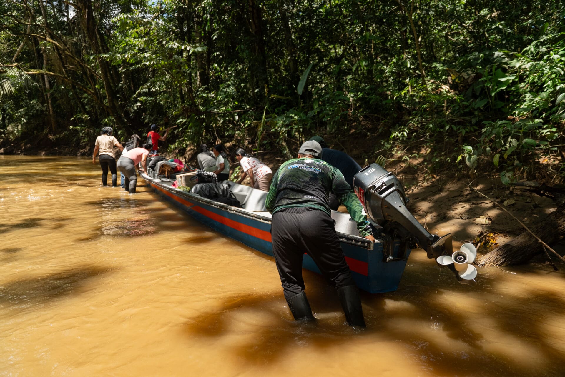
It is the last few days of July and, although according to the ecological calendar of the Coreguaje indigenous people it should be winter, Iles, leader of the Jácome indigenous reservation, says that the water level of the Jácome stream is as low as it is in summer, which is more typical of December. Along the nearly five kilometres they must travel by canoe from the Orteguaza River to the reservation, Iles and some members of the community will have to get out of the canoe repeatedly to push it through sections where the water barely reaches their knees.
 The journey from the turn-off on the Orteguaza to the reservation, home to 135 Coreguaje indigenous people, should not take more than an hour. But after three days of intense sunshine, the water level in the stream – which is no more than four metres wide – has almost doubled the journey time.
As he steers the boat, which winds its way slowly along, Iles points out where Lake Puñuchiara used to be – the largest in the municipality of Milán (the closest to the reservation) – which dried up completely some 20 years ago after the elders had intervened decades earlier in search of a transport route.

In addition to the drying up of the lagoon – which left them with nothing to fish – the indigenous leader highlights the deforestation for cattle farming that has increased in recent years around the reservation, and the impacts of climate change, which threatens to dry up the ravines on which they depend.
Journalists from El Espectador, Mongabay Latam and Correo del Caroní analysed the changes that have affected the Orteguaza over the last two decades, as well as three other Amazonian rivers, with support from scientists at MapBiomas and the quantitative ecology training programme at Brazil’s Serrapilheira Institute. They carried out this work as part of the ‘Divided Waters’ investigation, coordinated by the Latin American Centre for Investigative Journalism (CLIP) in partnership with eight media organisations across the region.
In total, this journalistic alliance analyzed 722 micro-watersheds in four countries—62% of which are territories inhabited by at least 96 indigenous peoples—using the micro-watershed analysis from the Amazon Network for Georeferenced Socio-Environmental Information (RAISG), based on data from the MapBiomas Agua platform. The results are striking. In Bolivia, micro-watersheds with illegal mining gained 21.5% of their water surface area over 25 years, while those with no mining lost 17.2%. In Venezuela, the total water volume of the 98 tributaries and reservoirs along the Caroní River fell by 5.8%, according to data from MapBiomas Venezuela. Since more than three-quarters of the Caroní’s water is contained by three large hydroelectric power plants (Guri, Macagua, and Caruachi), this fact masks a significantly larger loss of water in the rivers. In Peru, 99.7% of the new artificial water is concentrated in 45 of the 84 micro-watersheds studied, which have both legal and registered illegal mining activities.
Across the four watersheds, using the same methodology, a more nuanced pattern emerges: one in six micro-watersheds loses natural water and gains artificial water at the same time, in the same location.
The Caquetá is also one of the basins with the highest indigenous presence in the study: 68% of its micro-basins contain territories belonging to at least 50 indigenous groups, spread across 124 reserves and indigenous lands. The Jácome joint-management reserve is one of them.
The shortcut that led to scarcity
According to the accounts of some of the community’s elders, the first Coreguaje indigenous people (“healthy people”, in their language) to arrive in the lands of the Jácome reservation did so towards the end of the 1950s. They came from Getuchá, an indigenous community near San Antonio de Getuchá, in the rural area of the municipality of Milán, 30 kilometres south of the regional capital, Florencia.
Lázaro Ibáñez Moreno describes himself as a “farmer, chainsaw operator and traditional healer” from the Jácome indigenous reservation. He was one of the first to be born in the new settlement. Now aged 58, he recalls that in his childhood, both banks of the River Orteguaza and the Jácome stream were full of trees, and there were hardly any “beaches” or “sandbanks” – as they refer to the riverbed exposed when the water level is low.

In the river, the stream and the lagoon alike, Ibáñez claims to have easily caught lecheros and pintadillos (two types of catfish) and plateados (a type of cichlid) weighing up to 115 kilograms. Adel Iles, aged 36, recalls catching, alongside his father, fish such as cheos (Leporinus bimaculatus) and nicuros (Pimelodus blochii) measuring over 50 centimetres, as well as puñus ( Serrasalmus rhombeus), a large species of piranha which, due to its large population in the lagoon, the community eventually christened Puñuchiara.
Although the lagoon was the ‘largest and most beautiful’ in the municipality of Milán, as some of the older residents recall, it had one drawback: it was not possible to cross it from the community, as there was no channel connecting it to the River Orteguaza, which forced them to make a longer journey to reach the river and then sail on to San Antonio de Getuchá, the village that remains the main centre for trade and supplies for the community.
Iles estimates, based on the accounts of some of the elders, that around 40 years ago the community organised a minga (communal work) and, using spades and rakes, worked for a couple of months to dig an artificial canal to connect the lagoon to the Orteguaza. Over time, the canal became a waterway that helped reduce both the journey time and petrol costs between the community and the main river.
However, as the years went by (as can be seen in the illustration below), the lagoon gradually filled with sand until, approximately 20 years ago, it dried up almost completely, leaving only seasonal puddles.
The lagoon’s water surface area exceeded 10 hectares in 1998, according to data from the MapBiomas platform, created by a consortium of Amazonian non-governmental organisations that maps changes in land use and the evolution of water bodies due to various pressures. By 2024, its area had shrunk to just 0.89 hectares.
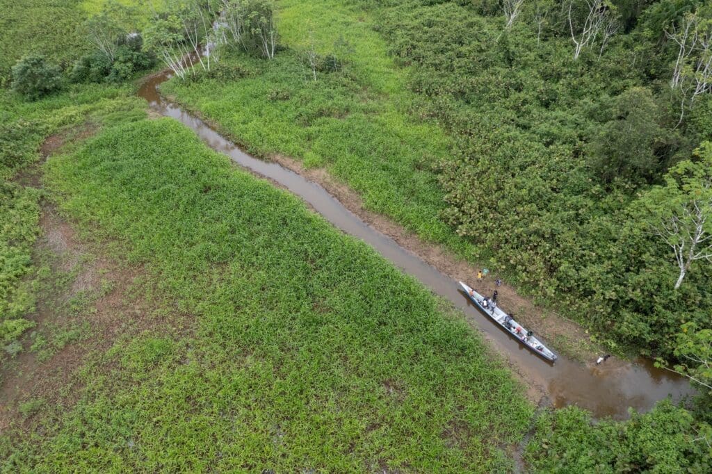
is now dominated by grasslands and a fledgling forest. / Terumoto Fukuda.
With the canoe moored at the edge of the forest that has now taken over much of the lagoon, Iles explains that “it’s very difficult to find a cucha (Hypostomus niceforoi) here now. Not even the silver mojarra (a type of cichlid), which used to be one of the most abundant species. And you can still find nicuros, but they’re only about 15 centimetres long – ‘tiny’ ones”.
Claudia Patricia Ibáñez, a cacica (leader) of the indigenous reservation who was also part of the delegation organised to visit what remains of Puñuchiara, adds that “there used to be plenty of fish, but you can’t find any nowadays”.
“Children hardly want to go fishing anymore because you can’t find ‘dentones’ (Hydrolycus scomberoides) or ‘bocachicos’ (Prochilodus nigricans). There are only tiny sardines left,” continues Ibáñez, referring to various types of fish no longer than 10 centimetres.

After exchanging a few words with some of the elders in Coreguaje, the local expert Lázaro Ibáñez highlights the impact this situation has had on the community’s food supply. Now, he adds, in order to fish they have to travel as far as Orteguaza, which means having petrol for the motorised canoe. When there is none, the journey involves a couple of hours’ rowing each way.
A growing problem
In the early 1990s, whilst the community was beginning to notice how the artificial canal was draining the lagoon, the now-defunct Colombian Institute for Agrarian Reform (Incora) legally established the Coreguaje Jácome Indigenous reservation, with an initial area of just over 310 hectares.
By the mid-1990s, Ibáñez estimates, the transformation of the land surrounding the reservation was becoming increasingly evident. “We used to look at the mountain by the riverbank,” he says, referring to the dense forest that stretched right up to the banks of the stream. “But then the cattle came and started cutting it all down, and now all you can see is pastureland; there are hardly any trees left,” adds the local expert.

Caquetá, along with Putumayo, was one of the first departments in the Colombian Amazon to see the introduction of cattle around the 18th century, according to Roberto Ramírez Montenegro, a sociologist and lecturer at the University of the Amazon, in an article published in June 2024. The consolidation of cattle farming took place from the second half of the 20th century onwards, driven by colonisation policies promoted by the Colombian state and financially supported by multilateral organisations such as the World Bank.
To put this into perspective, since 2001 – when the Colombian Agricultural Institute (ICA) first began recording the total cattle and buffalo population – Caquetá has been, by far, the Amazonian department with the largest number of livestock, bearing in mind that not all municipalities in Meta – a department with a long history of cattle farming – are part of the Amazon region. In 2001, across the six departments that make up this region (as well as in municipalities in four other departments within it), there were just over 2.98 million animals. Of these, 44.3% and 43.41% were in Meta and Caquetá, respectively. In other words, nine out of every ten head.
Whilst Caquetá has historically been a cattle-rearing region — unlike the rest of the Amazonian departments — over the last decade its herd has been growing at the same rapid pace as the rest of the Colombian Amazon, as noted by a researcher from the Foundation for Conservation and Sustainable Development (FCDS), who has asked to remain anonymous to avoid reprisals.
In 2016, the researcher says, “there was a fundamental shift following the signing of the Peace Agreement between the Colombian state and the FARC guerrilla group. That process led to a complete reconfiguration of actors, power structures and, in general, territorial dynamics in the Amazon”.
Since that year, organisations such as the FCDS have noted that the growth in cattle herds in the Amazonian departments – and, above all, in the municipalities forming part of the Amazon Deforestation Arc, where the greatest loss of forest is concentrated (across Meta, Guaviare and Caquetá) – has been above the national average. In the specific case of Caquetá, between 2016 and 2025, the cattle herd increased by 72%, according to figures published by the ICA. This confirmed it as the fourth department with the highest number of cows in the country.
Chieftain Claudia Patricia Ibáñez, the traditional healer Lázaro Ibáñez, Adel Iles, along with some elders and young people, are discussing a map of the reservation and the surrounding land, where deforestation for cattle farming is concentrated. After several minutes of discussion in the Coreguaje language – which dominates conversations amongst the members of this community, who refuse to replace it with Spanish – Iles speaks up to translate what has been said.
In detail, he begins to trace the boundaries of their reservation with his finger – which, since November 2024, has covered just over 1,000 hectares – to name, first and last, the owners of the farms surrounding them and on which cattle are currently grazed. After highlighting the land to the east, moving on to that to the north and finally reaching the land to the west, Iles sums up the situation: “To put it simply, all of this is pastureland. We’re surrounded by cattle farms.”

The community’s experience is consistent with an analysis of satellite imagery from the last decade carried out by scientists at MapBiomas.
According to MapBiomas, during this period there has been a gradual transformation of the land within a five-kilometre radius of the reservation. “Whilst in 2016 relatively continuous and homogeneous forest cover predominated around the reservation, by 2024 a greater presence of clear, fragmented and heterogeneous areas can be observed, particularly in the northern, southern and south-western sectors of the area of influence,” it noted.
This transformation, MapBiomas adds, “exhibits specific patterns consistent with processes of clearing and consolidation of land designated for agricultural and livestock activities”. The spatial analysis, the platform’s researchers continue, takes on greater significance when the evolution of the cattle inventory recorded for the municipality of Milán is factored into the analysis: between 2016 and 2025, it shows an increase of 53.4%.
After integrating the satellite image analyses with the cattle stock figures, MapBiomas notes that “the period of greatest increase in cattle stock coincides temporally with the stage at which the transformation of land cover becomes most evident”.
After making our way through a dense jungle – where it is at times difficult to make headway whilst dodging the roots of trees protruding from the ground – our arrival at a pasture where just a couple of trees are barely visible marks the boundary of the reservation. These are the lands of a settler, dominated by unevenly growing grass and hundreds of brushwood which, as Iles points out, show that the land was sprayed a few days ago. This is the first step before the cattle arrive.
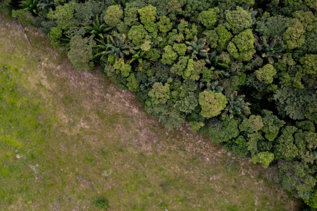
To see the cattle, one must walk for just over an hour, crossing several adjoining farms where there is nothing but the houses where their caretakers live. After this time, the indigenous group accompanying this tour begins to spot a few groups of cows on the horizon. Most of them, seen from a distance, number no more than 15 heads.

Terumoto Fukuda
For the Coreguaje indigenous community, deforestation and cattle farming have not only ecological but also spiritual implications. Chief Ibáñez sums up the primary impact in simple terms: “Where the trees are felled, the lakes and headwaters dry up – and that is where the water comes from.”
According to the Food and Agriculture Organisation of the United Nations (FAO), forests help to regulate water flow; reduce soil erosion and sedimentation in watercourses; promote groundwater recharge; and contribute to the recycling of atmospheric water, including cloud formation and precipitation through evapotranspiration.
In this regard, the UN agency adds that deforestation “may lead to an increase in water yield in the short term, but may also reduce annual yield in the long term, affecting both nearby and distant water supplies”.
In the micro-watershed where the reservation is located—that of the Orteguaza and Peneya rivers—the water surface area story. Deforestation, cattle ranching, and climate change are among the factors that could explain this decline, although satellite analysis alone does not allow us to pinpoint a single cause.
The micro-watershed that runs through Jácome lost the most water of any in Colombian stretch of the Caquetá river, nearly half of its surface area in two decades. Unlike the Amazonian watersheds where water disappears due to mining, in this case, the loss has happened at the same time as deforestation and cattle ranching. Across the entire Colombian stretch of the Caquetá river—the 167 micro-watersheds within the country’s territory—8,058 hectares of water surface area were lost during that same period, according to the analysis conducted for this investigation.
When measuring the 1.5-kilometer area around the reservation (excluding the lagoon, which was slightly farther from that perimeter), MapBiomas’ figures indicate that in 1998 there were 9.65 hectares of water surface area. By 2024, this had fallen to no more than 0.27 hectares.

Major Ibáñez goes on to say that the water has also diminished because the spirits that guard it (a great serpent, according to the Coreguaje worldview) have abandoned the places where they used to dwell, disturbed by the felling of the forest and the presence of livestock.
Alongside the increased sedimentation in the Jácome stream—which prevents the community from using the water at certain times of the day—reservation leaders have noticed a change in the water’s taste and temperature, which has even led to the suspension of water use at some points. “In some places you can’t drink it, even though we carry on drinking water straight from any little stream,” adds Iles.

Although the indigenous people of the Jácome reservation do not have any studies assessing the physical, chemical or microbiological properties of the water they drink – which would help determine whether it is safe for human consumption – they have observed a recurrence of illnesses such as diarrhoea and vomiting, as well as the appearance of fungal skin infections. They suspect that these symptoms are caused by sedimentation in the lagoon, water contamination from animal faeces, and the chemicals used on livestock farms for spraying, which fall or run off into the stream.
When summer was summer
In the conversations held in Coreguaje by the indigenous people of the Jácome reservation, snippets of Spanish often slip in. ‘Climate change’ is one. Although their mother tongue has no direct translation for this term, Iles acknowledges that his community began to feel the impacts of this global phenomenon several years ago.
“In the past, when it was summer, it was summer,” says the leader, referring to the dry season that used to run from October to the end of April. And “winter”, he adds, which lasted from May to July, “was winter – not like now, when it’s sunny for several hours and then it rains shortly afterwards. Before, winter was a wet season when all the rivers would burst their banks and everything was like a lake in those mountains.” August and September were months of transition, known in the region as “short summer”.

“Now, after three days of sunshine, the stream dries up. To see it at the levels it’s at now [in July], we used to have to wait until December, when several months of summer had already passed,” says Iles. Around this time in late July, chieftain Ibáñez, who also acts as a spiritual harmonizer in the community, asks the spirits for a couple of days of rain so that the level of the stream rises and allows visitors to leave.
In late October 2025, the Amazonian Institute for Scientific Research (SINCHI), a state-run research centre focused on the Colombian Amazon, announced the results of a study on climate vulnerability and risk in Caquetá. Although the study is not publicly available, SINCHI stated that hydrographic sub-zones such as that of the Orteguaza River, amongst others, “pose a very high climate risk if current trends in climate change and patterns of land use and transformation continue”.
This situation, the Institute noted in a summary of the research sent to this journalistic team, “is exacerbated by the increased frequency of extreme events, heatwaves, droughts and more intense rainfall over short periods, as well as the accelerated loss of natural cover — such as forests and wetlands — which are being replaced by grassland and crops”.
The increasing frequency and magnitude of extreme events, coupled with the unpredictability of weather patterns, has not only disrupted the ecological calendar of the Jácome indigenous reservation but, as Chief Ibáñez points out, has also profoundly affected the chagra, a farming area that underpins the community’s food sovereignty and is, at the same time, vital for passing on knowledge to new generations, as defined by Tropenbos Colombia, an organisation with over three decades’ experience of working with indigenous communities in the Colombian Amazon.
Having stable summer and winter seasons used to allow for the planning of land preparation, sowing seeds and harvesting food, explains the chief. Now, it is more difficult to stick to the chagra cycle, which depends on the ecological calendar. The reason is that extreme droughts and heatwaves have reduced the resilience of several crops on which they depend, such as maize. “All these changes have meant that we no longer have the same sense of security that we used to have,” adds Iles.
In last year’s study, the SINCHI Institute recommended, as a matter of urgent priority, that progress be made in the Orteguaza river basin towards restoring vegetation cover, with the aim of increasing the size and number of forest patches.
Years before the scientific institute reached that conclusion, the Coreguaje community of Jácome had already begun ecological restoration processes – another couple of terms they borrowed from Spanish. The first attempt, around a decade ago, did not yield good results, as the community recalls.
Around 2023, the community began to receive financial support from the Ministry of the Environment and training from the National Learning Service (SENA), a national public institution that offers free technical and technological education, in ecological restoration and the establishment of plant nurseries.

In addition to the 120 hectares set aside exclusively for the ecological restoration of the rainforest in this transitional region between the Andes and the Amazon, the community has more than 40,800 seedlings of 25 native species, including fruit trees such as the chontaduro (peach palm), caimarona grapes, cashew and cherimoya, and timber trees such as ahumado (black manwood), cedar and perillo (cow tree).
Whilst the community is eagerly awaiting the progress of the restoration work, Major Lázaro Ibáñez and Chief Claudia Patricia Ibáñez are calling on the local and departmental governments to help them establish communication with the settlers living nearby who keep livestock on their farms. Both leaders point out that, in order to protect the water sources on which they depend, the cattle farmers should allow them to restore parts of the streams and springs located on their land. However, no such dialogue has taken place so far, and they claim that neighbours have torpedoed the planting carried out by the community outside the boundaries of the reservation, by uprooting or spraying the seedlings.

For the FCDS researcher, the case of the Jácome reservation, surrounded by cattle ranches, reveals “the contradictory approach the Colombian state has historically taken towards the Amazon”. On the one hand, he highlights that the state promotes conservation and ecological restoration programmes. At the same time, however, he questions why state bodies such as the Fund for the Financing of the Agricultural and Livestock Sector (FINAGRO) continue to grant agricultural and livestock loans specifically targeted at cattle farming in environmentally sensitive areas of the country.
Between August 2018 and October 2025, the Colombian government invested at least 1.5 trillion pesos (around 466 million dollars) in loans for the livestock sector in the Amazon region through Finagro, according to a journalistic investigation by La Silla Vacía published in February this year. “A completely contradictory stance,” asserts the researcher.
Finagro told this journalistic alliance that in the coming days it will be publishing the results of a study carried out in conjunction with the Ministry of the Environment and the Institute of Hydrology, Meteorology and Environmental Studies (Ideam), in which the research question was precisely whether there is a causal link between livestock loans and deforestation at municipal level in the Amazon biome.
Regardless of the study’s findings, Finagro stated that it is implementing measures to ensure the protection of Amazonian ecosystems, as well as “strict controls that prevent any attempt to finance illicit activities or the irregular expansion of the agricultural frontier”. The organisation adds that the ongoing assessment of its portfolio “aims to consolidate the transition towards a sustainable economy in the region”.
Whilst the leaders of the Jácome reservation seek an institutional response that will enable them to build bridges with neighbouring settlers, Iles highlights a species in his nursery for restoration: the canangucha (Mauritia flexuosa), also known as Mauritia palm, moriche or buriti. With this palm, which forms large forests that are key to water regulation and storage, the community hopes to filter the water they consume and once again attract certain species of fish.

“What we’re aiming for, first and foremost, is to establish a forest at least along the banks of the stream. Then, we hope that the owner of that place – the spirit – will also return. It will be the spirit who helps us restore the water to its proper level,” explains Iles.
Although it will be years before the land regains the right conditions for the spirit to return and inhabit it, it seems that the rain spirits heeded Major Ibáñez’s call. After a few hours of heavy downpours, the return journey along the Jácome stream in search of the Orteguaza River encountered no major obstacles. Four days after their arrival, the visitors’ tour takes an hour – exactly as expected for the month of July.
Scientific References
Data and Methodology for This Research
- Aguas Partidas (2026). A journalism project coordinated by the Latin American Center for Investigative Journalism (CLIP), in partnership with Mongabay Latam, El Espectador, Correo del Caroní, and the Serrapilheira Institute (Brazil). Based on data from MapBiomas Água (Pan-Amazon collection and national collections), RAISG (analysis by micro-basins, indigenous territories, mining, and deforestation), and HydroBASINS/HydroATLAS Level 8 (WWF).

This project is the result of a collaboration between Latin American journalists and scientists, spearheaded by Brazil’s Serrapilheira Institute and the Latin American Center for Investigative Journalism (CLIP), to explore the Atlantic-Amazon-Andes water pathway and the disruptions to the ecosystem services it provides to the continent.


